
- Who is the Surveyor General of India?
- Functions of Surveyor General of India?
- Where is Sea of Japan/East Sea?
- Why Japan Sagar controversy?
- Arguments: Japan vs S.Korea
- India’s Stand on Sea of Japan
- Food for thought
- Mock Questions
Who is the Surveyor General of India?
- Survey of India is the India’s official map-making agency.
- It functions under the Department of Science & Technology
- HQ= Dehra Dun
- Its Officers are appointed through Indian Engineering Services Examination conducted by UPSC.
- Head of this map making agency, is called Surveyor General of India.
Functions of Surveyor General?
- Acts as adviser to the Government of India on all survey matters.
- Produces Geographical maps and Aeronautical Charts.
- Demarcates the External Boundaries of India.
- Advice on the demarcation of inter-state boundaries.
- Predicts tides at various ports.
- Publishes Tide Table one year in advance to support navigational activities.
- Certifies maps published by private publishers.
- Surveys for Developmental Projects.
- Research and Development in Digital Mapping.
Where is Sea of Japan/East Sea?
- A marginal sea of the western Pacific Ocean
- It is bordered by Japan, North Korea, Russia and South Korea.
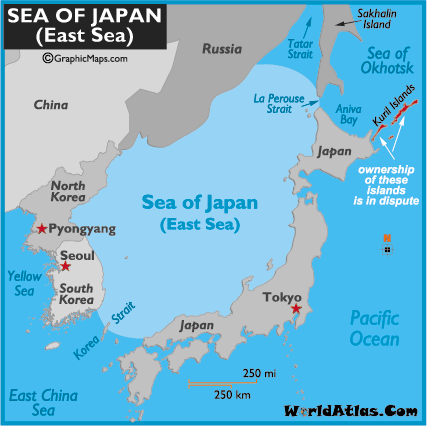
Japan Sagar controversy?
- Survey of India, has omitted naming this sea/water body in its English version, though the Hindi one calls the area ‘Japan Sagar’ on its maps.
- Japan has protested against this.
- In case you wonder, what is there in a “name”, well recall the earlier article Liancourt Rocks/ Takeshima/ Dokdo Islets Dispute Between Japan and South Korea (Click Me)
- Sea of Japan has valuable fishing grounds.
- The seabed of the area contains vast, untapped reserves of gas hydrates.
- So it is not just about a name but about the money involved as well.
Arguments: Japan vs S.Korea
| Japan | S.Korea |
|---|---|
|
|
| United Nations recognised “Sea of Japan” as the standard geographical term in March 2004. | The term used by UN Secretariat to refer to a place, does not in any way constitute an official position or policy. |
| But the governments of the US, the UK, France, Germany and China also use the name “Sea of Japan”! | Ya but governments of these countries have officially stated that naming the sea area between the Korea and Japan should be settled by agreement among the countries concerned. |
|
India’s Stand on Sea of Japan
- Ministry of External Affairs clarified on the issue, “As far as India is concerned, there is no change in our policy. Name of that water body is Sea of Japan.”
- But at the same time, Ministry of External Affairs (MEA) is unlikely to pursue the matter with the Survey of India. (however Japanese Embassy would take up the issue to Surveyor General).
Food for thought
- India can hardly claim that Japan is over-reacting when it is so quick to take umbrage over cartographical errors, deliberate and otherwise, related to its territories. (Maps showing Azad Kashmir or Arunanchal Pradesh shown in China).
- It is not uncommon for countries to fight their battles over disputed territories by proxy, through maps. But sometimes maps can solve as many problems as they create.
- Recall the earlier article on Senkaku/Diaoyu islands (China vs Japan) click ME
- At the height of that dispute between China and Japan over islands in the East China Sea, Apple’s new mapping software presented a novel solution: duplication.
- It simply showed two sets of the islands appearing next to each other — one for Japan and one for China!
Mock Questions
Which of the following statements are correct?
- Sea of Japan is bordered by Japan, North Korea, Russia, China and South Korea.
- Survey General of India, is responsible for predicting tides at ports and preparing tide-tables for navigational purposes.
- Surveyor General of India, falls under the jurisdiction of Ministry of Earth Sciences.
- Anthropological Survey of India is a premier research organisation under the Ministry of Culture
- Botanical Survey of India (BSI) is the apex research organization under the Ministry of Agriculture.
Mains
- Survey of India (5 marks)
- International Hydrographic Organisation (IHO) (5 marks)
- Discuss Indo-Japan relations, in the light of DMIC, NPT and Sea of Japan. (25 marks)
Essay
- Wars of nations are fought to change maps. But wars of poverty are fought to map change.
- Maps can solve as many problems as they create.
![[IR By Pavneet 4/5] Art of Answer-writing: Directive Word#2 “DISCUSS” – Impediments to India’s permanent membership at UN Security Council (UNSC)](https://mrunal.org/wp-content/uploads/2018/07/webinar-pvnt-c-500x383.png)
Hold tight aspirants., Finally confirmation about optional presence is gonna reveal in 15 days.
i mean optional subjects
How do you know?
was informed by my coaching center (AP). He went to delhi and came back with this news.I hope hes right.I will inform here after 14 days about that news again.
hw do u know b
how do you know?????
n
y
n
y
n
your answer is correct.
The 1st question in essay is excellent. It is well framed just like the UPSC would do. I am sure that this can be well practised. Another suggestion to you Mrunal is maybe nearing the next year Mains you can collect all your suggestions into one post and also provide the “Click Me” links near them so that aspirants can practise or at least know the current topics.
ur mains ques here really gud in approach.
1st topic in essay is like that in upsc.
thnx for “click me”, they are a big help.
Nice reading. Thanks
Hi Mrunal sir,
Do you have any update regarding removal of optional’s from mains?
If no,what your personal views sir ..please help.
Same Question….
I’m still waiting for R.T.I reply
And when are you expecting it??
Mrunal sir,
I also have said if no then what’s your views regarding Optional,
Dont you act awesome like A Raja and Kanimozhi ha ha…:P
bc dont halt my studies
Again thanks Sir :) I become your fan :) ..
sir,
if a country naming a sea on its own,then can it claim the natural resources in international water,if not,what is the significance of naming a sea and fighting for that…?
Mrunal sir,
I also have said if no then what’s your views regarding Optional,
Dont you act awesome like A Raja and Kanimozhi ha ha…:P
I’m waiting for the R.T.I reply
thanku sir
sir do u provide hard copy of your material? Do u write any magazine.. Plz reply soon
No.
But you can get PDF version of every article by clicking on the Print/PDF button on the top-right hand side corner.
thanks mrunal.
no articles of diplomacy 2014?