
- What is cloudburst?
- Why Himalayan Tsunami is a man-made disaster?
- Can we Predict Cloudbursts?
- Doppler Weather Radar (DWR)
- Crisis Mapping
- Google Person Finder
What is cloudburst?
- Extreme amount of precipitation
- in a short span of time.
- creates flash-flood conditions.
- Often accompanied by thunder and lightning.
Why cloudburst?
- A cloudburst can occur anytime and at any place which is affected by convective weather systems.
- India surrounded by oceans from three sides. Hence favorable location for convective weather systems.
| Convective weather system in: | result |
|---|---|
| Bay of Bengal | rainfall over the Indian subcontinent |
| Western Pacific Ocean | Diverts rain-bearing winds away from the Indian subcontinent. |
- During Cloudburst, massive coagulated clouds with heavy water content hover, over a very small location.
- The dead weight of the cloud is so massive and unbearable that it simply collapses under its own weight=>extreme precipitation within a short span of time=>flash flood.
| MONTH | WHAT HAPPENED? |
|---|---|
| March April May 2013 | heavy snow in Himalayas |
| 14-16 June 2013 | Non-stop Intense rainfall. It helped the snow to melt fast from Chorabari Glarier. but How can water help ice melt?
|
| 16 June 2013 | Cloudburst over Chorabari Lake. Lake exploded from water. => flash floods. |
- These flash floods washed the mud, stones and slush (Partially melted snow) from mountains into rivers.
- Bhagirathi, Alaknanda and Mandakini rivers were already flowing with lot of water (due to snow-melting).
Now imagine two situations:
- Police uses water cannon on the mob.
- Police mixes stones, ball bearings and ice cubes into their water tank and then uses water cannon on the mob. This time, you know the water will hurt a lot more.
Same way, the rivers filled with mud, snow, ice- rushes through the hills and cliffs- they will cause more erosion, sweep away whatever comes in their way. Thus, all those shops, hotels, apartments were constructed very close to the river banks got washed away.
Additionally landslides destroyed the road network in the mountains hence relief couldnot reach on time.
Why Himalayan Tsunami is a man-made disaster?
Cloudbursts have happened in past also, but the amount of death and damage in Uttarakhand is unprecedented. Why?
#1: Roads causing landslides
Himalayan Mountains will remain steady if not tampered with much. But
- the huge expansion of roads and transport.
- heavy machines plying the earth everyday.
- Even dynamites are used to cut the mountains and make roads.
^All these activities had already rendered the mountains unstable. Then rainfall=>landslides. roads blocked=rescue force can’t go in, victims can’t go out.
#2: Too much construction
- In 2012, Ministry of Environment and Forests gives a notification under Environment Protection Act. This notification declares the region Gaumukh and Uttarakashi, along the Bhagirathi river, as an eco-sensitive zone. Meaning following activities had to be banned:
- Hydro project in Bhagirathi = too many hydropower projects, changing river courses, poor structural safety
- Mining= use of dynamites, weakened the mountains
- Construction activities, especially hotels and resorts, guest houses and travel lodges on the river bed. Everyone trying to make mint money from pilgrims/tourists yet none of them were build with sound engineering or structural safety.
#3: Fragile Polity of the State
- Uttarakhand has seen 6 different Chief Ministers within last 13 years. Meaning average tenure of a CM is ~2 years.
- This has resulted in lack of continuity and failure in getting a firm grip on the issues plaguing the state- including disaster management.
- Successive CAG reports have made scathing remarks on the lack of disaster management preparations in the Uttarakhand state. Yet no action was taken.
- political fragility has resulted in ad-hoc and unplanned development.
- Successive governments have failed in creating any sort of medium term or long-term plan or vision for the state.
- To put this in other words, when governments change too quick- the main goal of MLAs and Ministers is how to extract maximum cash from builders, mining mafias and corrupt bureaucrats who want transfer-posting in plump position. Hence, Disaster management doesn’t even come in their top-100 priority list of such politicians.
#4: Careless organizations
|
|
|
|
Overall, there was no accountability and no coordination.
Can we Predict Cloudbursts?
- Nephology=study of clouds
- But unlike cyclones, forecasting a cloudburst= mission almost impossible.
- Cloudburst can occur even outside the monsoon seasons (e.g. March to May, if the weather conditions are right).
- A cloudburst can occur @anytime @anyplace in a short span of time. (but it usually favors mountainous regions)
- The specific location and time of cloud burst can be predicted in NOWCAST mode only, i.e. a few hours in advance.
- To detect these sudden developments, you need a Doppler Weather Radar (DWR).
Doppler Weather Radar (DWR)
By and large, Meteorologists use there are three different types of weather radars:
| RADAR | UTILITY |
|---|---|
|
gives information only about the rainfall estimation |
|
Measuring rainfall, winds and clouds. |
|
measure , winds, rainfall (including shape and number of raindrops) |
- One Doppler Weather Radar costs ~10 crore, can cover an area ~400 km.
- IMD wants to modernize its Radar system. BHEL is manufacturing S-Band Doppler Radars for IMD. They’ll be setup a 12 locations across India, including Mumbai.
- And since the Uttarakhand Tragedy, now Department of Sci-Tech is setting up Doppler Weather radars in Himalayas
Benefits of Doppler Weather Radar?
- Radar uses the Doppler Effect in microwaves. When Microwaves are reflected from objects at different times, this Radar detects their relative position. Thus Doppler Radar can detect even tiny water particles in clouds and in which direction they’re moving.
- Doppler radar has a detection range of ~400 kms. It can transmit information about a cloud, its distance from land, its composition, which direction it is moving and even minute details like the number and size of water droplets found in a cloud.
- We can predict the amount of rainfall to an area, 2-3 hours in advance. Thus, if a flood-like situation is likely to happen in Mumbai, BMC could be alerted to avert a 2005-like disaster.
- can predict thunderstorms as well.
Crisis Mapping
- Crisis mapping is the real-time data gathering and analysis during natural disaster or riots, elections etc.
- During Uttarakhand tragedy, International Network of Crisis Mappers came to help.
- These crisis mappers monitor different channels of information on Uttarakhand. Example
- official sources,
- blogs, social media, facebook twitter
- NGOs
- news media
Using such data, the Crisis Mappers generate ‘situation reports’
They also update with vital information an online crisis map set up by the Google: (http://google.org/crisismap/2013-uttrakhand-floods? gl=in)
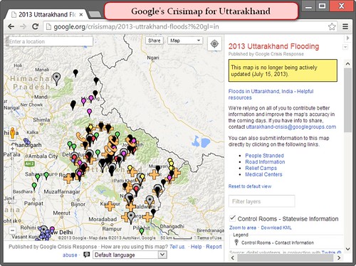
- ^That google crisis map has information on rescued people, cleared areas, people stranded, relief camps, medical centres, road networks and so on.
- Thus, crisis mapping helps bridge the gap between
- information-seekers vs providers
- government vs public
- situation on the ground vs action that needs to be taken
- Ushahidi = open-source platform for crisis mapping during 2010 Haiti Earthquake. They even had an international SMS number was created for people to input information relating to the quake.
Google Person Finder
- Google Person Finder is a web application available in Hindi and English. (link: http://google.org/personfinder/)
- Allows individuals to post and search for the status of relatives or friends affected by a disaster.
- All data entered into Google Person Finder is available to the public and searchable by anyone.
- Also lets Press agencies, non-governmental agencies etc. contribute to the database and receive updates. This was utilized during rescue & relief operations in Uttrakhand tsunami.
![[Environment] Mangrove Species Conocarpus banned in Gujarat & Telangana](https://mrunal.org/wp-content/uploads/2023/09/edp-conocarpus-500x383.png)
![[Environment] Floating Solar Farms, Banni Grassland, Nairobi flies & more Weekly Mrunal Digest from Jul week1-2022 (WMD)](https://mrunal.org/wp-content/uploads/2022/07/Floating-Solar-Farm-500x383.webp)
![[Environment WMD] Single use plastic ban, ESZ, Surya Nutan Cooker, & more from Jun week3-2022](https://mrunal.org/wp-content/uploads/2022/07/single-use-plastic-main-500x383.jpg)
![[T25] UPSC Mock Round#43: Environment & Geography Practice Questions- Global Climate Risk Index 2020, Bog wetland and More](https://mrunal.org/wp-content/uploads/2018/12/c-t25-taimur-500x383.jpg)
Sir can u please suggest a site to refer to for international events.
Eg for polity prsindia..
Ministry of external affairs official website
idsa…..:-)
sir can you suggest books and material for ethics and world history
hi.. i need to write a research paper on uttrakhand almost everything is covered. can u suggest me some primary data?