
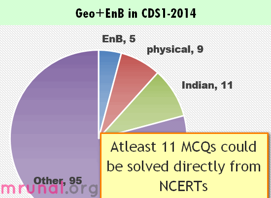
- Geo+ EnB in CDS vs CAPF vs CSAT
- Geo+EnB: Internal breakup
- Span of Current affairs Geo/EnB MCQs
- Difficulty level of Geography / EnB MCQs
- Booklist/Strategy for next CDS Exam
- Physical Geography [9 MCQs]
- Indian Geography related [11MCQs]
- Environment & Biodiversity (EnB) [5MCQs]
Geography+ Environment in CDS vs CAPF vs CSAT
So far we are done with: History, Polity and Science MCQs from UPSC Combined Defense services (CDS) exam of 2014. You can see them at Mrunal.org/CDS
Moving on,
| Geography + EnB Topic | CDS1-2014 | CDS2-2013 | CDS1-2013 | CAPF-2013 | CSAT-2013 |
| Geo+EnB | 25 | 22 | 26 | 22 | 36 |
| total MCQs | 120 | 120 | 120 | 125 | 100 |
| % | 21% | 18% | 22% | 18% | 36% |
- In all exams, UPSC reserves nearly one fifth of the paper (20%) for Geography and environment-biodiversity related questions. (Except CSAT).
- Within CDS – the % weighage has remained almost the same for last three exams for Geo+EnB.
Geography+Environment: Internal breakup
| Physical Geography | Geology related | 6 |
| Climate related | 3 | |
| Physical subtotal: | 9 | |
| Indian | Water related | 4 |
| Mountains | 1 | |
| Map based | 2 | |
| Census related | 2 | |
| Agriculture | 2 | |
| Indian Geography Subtotal: | 11 | |
| Geography total (11+9) | 20 | |
| Environment & Biodiversity total | 6 | |
| Geo+EnB | 26 | |
- I have not separately counted “World geography” because (1) Haiyan Typhoon= in climate (2) Savanna Grassland =EnB
- Just like in Ancient History/Culture, UPSC has made unwritten rule that “we’ll ask alteast one MCQ from Jainism Buddhism”, similar in Geography- they seem to have an unwritten rule “we’ll ask atleast 2-3 ridiculously tough MCQs from geology” – be it CDS or CAPF or CAPF.
Span of Current affairs Geo/EnB MCQs
- Haiyan typhoon
- Kasturi Rangan report
Both news happened in November 2013. And CDS was conducted in February. So, the span of “current affairs” = alteast last 3 months before the exam. (picture will become more clear when we solve the PIN person in news type MCQs in next article.)
Difficulty level of Geography / EnB MCQs
Debatable. Depends on the preparation level of the person. I classify following as “Tough MCQs” because (a) trivial GK (b) not given in routine books that we use for preparation.
- saptrolite rocks
- clay aquifers
- Vishakhapattanam is land locked harbor.
- Valiconda hills location
Booklist/Strategy for next CDS Exam
- Atleast 11 out of 25 MCQs can be solved from NCERTs alone. =~50%. The breakup has been similar for science portion as well. (Nearly half of the MCQs can be solved from NCERTs)
- Do read NCERT sociology- because they asked population /census related MCQs from it.
- Do solve the MCQs given within NCERTs- because one MCQ on granite was directly lifted from its exercises.
Beyond NCERT, you can go for:
- Lucent GK (for dam, sanctuary related GK)
- School Atlas (For Map based questions)
- NIOS (although not “essential” given the level of EnB MCQs in last few CDS exams)
- do solve old CDS papers (because one MCQ on Valiconda was repeated from CDS1-2013)
Not recommended books
To solve some of these Geography MCQs, you need to refer books like Surender Singh, Majid Hussain, DR Khullar etc. BUT if you’re solely dedicated for CDS (and not giving Civil service exam), then DONOT you waste time and money in such advanced level geography books. Because
- Nearly 50% of the MCQs are from NCERTs.
- The cost: benefit become terrible. To solve those 4-5 advanced level MCQs, you’ll need to mugup ~500 additional pages full of trivial and boring details.
- You’re better off investing that much time and energy in polity, science, History, maths and English.
- You don’t have to tick 120/120 to get selected in this exam. Cutoff is not *that* high. (They keep cutoff relatively low- because lot of candidate fail in medical checkup.)
Anyways, lets start
Physical Geography [9 MCQs]
internal breakup:
| geology, minerals | 5 (two not solved yet) |
| earthquake | 1 |
| climate- India | 2 |
| climate-current (Haiyan typhoon) | 1 |
| total | 9 |
P1: Geology / Earthquake / Minerals related
Q1.Which one of the following is depositional landform?
- Stalagmite
- Lapis‑
- Sinkhole
- Cave
NCERT Class 11 ch7 page 65-66
Under depositional landforms, they’ve discussed Stalactites, Stalagmites and Pillars. Hence answer (A)
Q2. Which of the following is/are direct source(s) of information about the interior of the earth?
- Earthquake wave
- Volcano
- Gravitational force
- Earth magnetism
Select the correct answer using the code given below.
- 1 and 2 only
- 2 only
- 3 and 4 only
- 1, 2, 3 and 4
NCERT Class 11 ch3 page21-22
Under the topic titled “Source of information about the interior”, they’ve discussed
- Direct Sources => rocks, volcanic eruption,
- Indirect sources=> meterors, indirect sources include gravitation, magnetic field, and seismic activity.
Therefore, answer B: only 2 (Volcanoes).
Q3. Which of the following are the two main constituents of granite?
- Iron and silica
- Iron and silver
- Silica and aluminium
- Iron oxide and potassium
This MCQ is asked verbatim in the NCERT Class11 ch5’s exercise itself. But answer is not given verbatim. Anyways, Barkeley university gives the chemical composition:
Granite is typically 70-77% silica, 11-13% alumina, 3-5% potassium oxide, 3-5% soda, 1% lime, 2-3% total iron =>answer (C) silica aluminium.
Q4. Which of the following statements relating to earthquakes is/are correct?
- The point of origin of an earthquake is called the epicenter.
- The lines joining the places which were affected by earthquake at the same point of time are called homoseismal lines.
Select the correct answer using the code given below.
- 1 only
- 2 only
- Both 1 and 2
- Neither 1 nor 2

NCERT class7 ch3 fig.3.3 => point of origin = focus and not “epicentre” hence #1 is wrong.
Geography by Surinder Singh page 1.38=> second statement is right. therefore answer (B) only 2
haven’t solved
Q5.Consider the following statements:
- Weathered rock with change of volume is called saprolite.
- The process of landscape formation by deep weathering followed by stripping of the saprolite is called etching.
Which of the statements given is/are correct?
- 1 only
- 2 only
- Both 1 and 2
- Neither 1 nor 2
yaar itnaa detail mein kaun prepare kartaa hai?
#1 is wrong because
Weathering by Domenico Calcaterra, page a7, “Weathered rock with no volume change is called saprolite.”
#2: haven’t located a reliable source yet.
Q6. Consider the following statements :
- Statement I: Clay layers are poor aquifers.
- Statement II: The inter-particle space of clay minerals is the least.
Select the correct answer using the code given below.
- Both the Statements are individually true and Statement II is the correct explanation of Statement I
- Both the Statements are individually true but Statement II is not the correct explanation of Statement I
- Statement I is true but Statement II is false
- Statement I is false but Statement II is true
Environmental pollution, Ross M.Mickinney Page 112
Clay soils donot make good aquifers as the particles are too small for rapid movement of water. =>Hence A is right.
NCERT Class7 science, ch9 page 99: “Clay particles, being much smaller, pack tightly together, leaving little space for air.” => II is right.
and thus II (indirectly) explains I: therefore answer (A) = Both the Statements are individually true and Statement II is the correct explanation of Statement I.
Physical geo: Climate related
Q1. What would be the influence on the weather conditions when in mid-winter a feeble high pressure develops over the north-western part of India?
- High and dry winds would blow outward from this high pressure area.
- The northern plain would become cold.
- Scorching winds (locally called loo) would blow during the daytime.
- There would be torrential rains brought by thunderstorms.
Select the correct answer using the code given below.
- 1 and 2 only
- 2 and 3 only
- 3 and 4 only
- 1, 2, 3 and 4
NCERT Class 9 ch4, page 8
A striking feature of the hot weather season is the ‘loo’. These are strong, gusty, hot, dry winds blowing during the day over the north and northwestern India.
Meaning, loo blows during summer=>#3 is wrong, so B, C and D are automatically removed. we are left with answer (A).
Q2. Which of the following statements regarding the duration of day and night is correct?
- Difference is least near the Equator and progressively increases away from it
- Difference is maximum at the Equator and progressively decreases away from it
- Difference is least at the Tropics and progressively increases towards the Equator and Poles
- Difference is maximum at the Tropics and progressively decreases towards the Equator and Poles
NCERT class 9, ch1, page2
Why the difference between the durations of is day and night hardly felt at Kanniyakumari but not so in Kashmir?
that question itself expresses that difference is least near equator and more as we move away from equator =>answer (A)
Q3. On November 8, 2013, many people died in Philippines after a super typhoon ravaged the country. What was the name of the typhoon?
- Haiyan
- Utor
- Phailin
- Nesat
Answer: Haiyan. As per Hindu / Indianexpress
Indian Geography related [11MCQs]
internal breakup
| Water/drainage | 4 |
| mountains | 1 |
| map | 2 |
| census/population | 2 |
| agro | 2 |
| total | 11 |
India: Water/ Drainage related
Q1. Which of the following is /are west-flowing river(s) of India?
- Mahanadi
- Krishna
- Narmada
- Cauvery
Select the correct answer using the code given below.
- 1,2and4
- 2 and 3
- 3 only
- 1 and 3
Source#1: NCERT Class 9, ch3 page 5
Most of the major rivers of the Peninsula such as the Mahanadi, the Godavari, the Krishna and the Kaveri flow eastwards and drain into the Bay of Bengal.
Remove options accordingly, you’re left with answer C: only 3.
Source#2: India Yearbook, Ch1, Page3
| West Flowing | East Flowing |
| Tapi, Narmada | Godavari, Krishna, CAuveri, Mahanadi |
Accordingly, answer C: only 3 (Narmada)
Q2. Which one of the following dams is constructed across Krishna River?
- UkaiDam
- Krishnaraja Sagar Dam
- Srisailam Dam
- Mettur Dam
Answer is (C) as per this Sarkaari website
Q3.Match List-I with List-II and select the correct answer using the code given below the Lists:
| List-I(Irrigation/Power project) | List-II(River) |
| A.Bhakra Nangal | 1.Bhagirathi |
| B.Dul Hasti | 2.Mahanadi |
| C.Hirakud | 3.Chandra |
| D.Tehri | 4.Sultej |
answer choices
| A | B | C | D | |
| a | 4 | 2 | 3 | 1 |
| b | 4 | 3 | 2 | 1 |
| c | 1 | 3 | 2 | 4 |
| d | 1 | 2 | 3 | 4 |
Correct match:
| A4 Bhakra=Sutluj | NCERT class10 ch3 page4 |
| C2: Hirakud =Mahanadi | NCERT class10 ch3 page4 |
- There is only one choice where A4|__|C2 is given => answer (B)
- Other sources: tables given in Lucent (page 230-31) and TMH (page 125-26).
- By the way, books mention Dul Hasti = Chenab but Chandra = tributary of Chenab, where the dam is located.
Q3. Which one of the following is a landlocked harbour?
- Vishakhapatnam
- Ennore
- Mumbai
- Haldia
DR Khullar Page 842 “Vishakhapattanam is the deepest land locked port built at the coast of Andhra.”
Hence answer (A) correct.
India: Mountains
Q1. Valiconda low hills is a structural part of
- Nilgiri Hills
- Western Ghats
- Eastern-Ghats
- Cardamom Hills
Answer is Eastern ghats.
- Source #2: Oxford atlas page- 20 .
- source #3: Orient blackswan page16
Btw, it’s a Repeat question. In CDS1-2013 they had asked following…Veliconda Hills, which is a part of Eastern Ghats, is situated in—
- Odisha
- Tamil Nadu
- Karnataka
- Andhra Pradesh
Meaning Veliconda hills definitely in Eastern Ghats! => Answer (C)
India: Map based
Q1. Arrange the locations of four oil refineries of India from west to east.
- Koyali—Kochi—Panipat—Mathura
- Kochi—Koyali—Panipat—Mathura
- Koyali—Panipat—Kochi—Mathura
- Koyali—Panipat—Mathura—Kochi
See this map
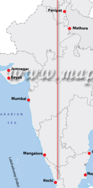
West: Koyali=>kochi=>Pani=>Mathu. Hence (A) is the right match.
source #2: DR Khullar Page 679.
Q2.Match List-I with List-II and select the correct answer using the code given below the Lists:
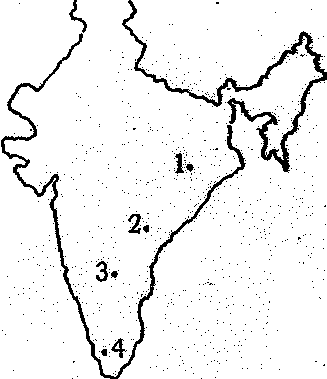
list I:
- A. Srisailam
- B. Sabarigiri
- C. Hirakud
- D. Sileru
Answer Codes:
| A(sri) | B(Sabri) | C(Hira) | D (sileru) | |
| a | 3 | 1 | 4 | 2 |
| b | 3 | 4 | 1 | 2 |
| c | 2 | 4 | 1 | 3 |
| d | 2 | 1 | 4 | 3 |
as per Orient Blackswan atlas, page 23. From North to South the order is:
- C1 Hirakud: Odi
- D2 Sileru: Andhra
- A3: Srisailam: Andhra
- B4: Sabrigiri: Kerala
Hence answer is B.
India: Census/Population related
Q1. Which of the following is /are the stage(s) of demographic transition?
- High death rate and birthrate, low growth rate
- Rapid decline in death rate, continued low birthrate, very low growth rate
- Rapid decline in birthrate, continued decline in death rate
- Low death rate and birthrate, low growth rate
Select the correct answer using the code given below.
- 1 only
- 1, 2 and 3
- 3 and 4
- 1 and 4
NCERT sociology ch12, chapter 2, page5-6
| stage | birth rate | death | growth |
| first | high | high | low |
| third | low | low | low |
- Meaning, #1 and #4 are right. There is only one option where both #1 and #4 are given together=> Answer (D).
- source #2: DR Khullar Page 333.
Q2. Population dividend refers to
- total number of population
- youthful age structure of a population
- relatively high proportion of experienced aged people
- migration from richer region to poorer region
Answer is (B).
- NCERT sociology ch12, chapter 2, page19
India: Agriculture related
Q1. Which of the following methods is/are suitable for soil conservation in hilly region?
- Terracing and contour bunding
- Shifting cultivation
- Contour ploughing
Select the correct answer using the code given below.
- 1 and 3 only
- 2 only
- 3 only
- 1, 2 and 3
Shifting cultivation (jhum) is not a soil conservation method. Infact it degrades the soils due to deforestation. #2 is wrong=> that eliminates B and D.
NIOS ch17, page 17:
- Terracing: It is another method of reducing or preventing soil erosion on mountain slopes.=>1 is right.
- Tilling the field at right angles to the slope called counter ploughing. Contour ploughing can reduce soil erosion by upto 50%.
Answer has to be (A) only 1 and 3.
Source #2: NCERT Geography Class 10, ch1
Source #3: Page 239 of Spectrum Geography
Q2. Which one of the following is the example of subsistence farming?
- Shifting cultivation
- Commercial farming
- Extensive and intensive farming
- Organic farming
Answer is A because
- Jhum=Shifting cultivation. (TMH Page 77)
- Shifting cultivation =primitive subsistence farming (NCERT class 10 ch4)
so, 1+2=answer A
Environment & Biodiversity (EnB) [6MCQs]
Q1. Biodiversity is richer in
- tropical regions
- polar regions
- temperate regions
- oceans
Page 261 of class 12th Biology NCERT
“species diversity decreases as we move away from the equator towards the poles. Tropics harbour more species than temperate or polar areas.”
That eliminates B and C. But what about A vs D?
According to National Geographic magazine: “species diversity is the common interpretation of biodiversity.”
So, if you compare by absolute number than “entire” oceans have highest number of species diversity than tropical regions alone. So answer => D. (or A, debatable since I’m unable to locate an exact source that compares ocean vs tropical). NIOS Ch15 talks about it but doesn’t compare ocean vs tropics.
Q2. Nitric oxide pollution can lead to all of the following, except
- leaf spotting in plants
- bronchitis-related respiratory problems in human
- production of corrosive gases through photochemical reaction
- silicosis in human
NCERT Class 11 Ch14 page 399
The irritant red haze in the traffic and congested places is due to oxides of nitrogen. Higher concentrations of NO2 damage the leaves of plants and retard the rate of photosynthesis. Nitrogen dioxide is a lung irritant that can lead to an acute respiratory disease in children. It is toxic to giving tissues also. Nitrogen dioxide is also harmful to various textile fibres and metals.
This automatically eliminates A and B.
What about C and D?
Britannica: “silicosis,a chronic disease of the lungs that is caused by the inhalation of silica dust over long periods of time. (Silica is the chief mineral constituent of sand and of many kinds of rock.)”
Hence answer (D).
Q3. The vegetation type characterized by (i) a large expanse of grassland with scattered trees and shrubs, (ii) lying between tropical rain forest and tropical steppes and deserts and (iii) flat-topped trees, is called
- mid-latitude broad-leaf mixed forest
- temperate rain forest
- tropical savanna
- mid-latitude grassland
Description lifted from Concise geography Majid Hussain page 4.7 =>answer is (C) Tropica savanna.
Q4. In a forest, animals like voles and wood lice feed on plant roots and barks respectively. Among the other carnivores, foxes, shrews and owls are present in that forest; following predictions-are made by a group of observers who have visited the forest:
- If the roots of the tree develop a disease, then voles and foxes will starve and not the owls.
- Population of voles is dependent on wood lice population through food web.
- If owl population declines, it will indirectly affect wood lice population.
- If barks of tree are affected due to a disease, then reduction of wood lice will affect the shrew population forcing owls to eat more voles.
Which of the above predictions is/are correct?
- 1, 2 and 4
- 2 only
- 1 and 2 only
- only 3
This thing is confusing. We should first make some table to get a better idea
| vole (one type of rodent) | eats plant roots |
| wood lice | eats bark |
| foxes, shrews, owls | eat meat |
Still picture not becoming clear, because we don’t know what exactly do foxes, shrews and owls eat.
According to Britannica and other web resources:
| Carnivore | what does it eat? |
| Owl | vole, lice, shrew |
| foxes | shrew, voles. (although one site even says foxes avoid shrew due to its foul taste. but let’s not nit-pick) |
| shrew | Lice and insects. |
One site even says that Voles eat barks also, especially in winter. but again let’s not nitpick.
Now let’s check the statements
- If the roots of the tree develop a disease, then voles and foxes will starve and not the owls. => wrong because roots develop disease then tree will die=>lice will also die. owl will suffer. Hence #1 is wrong=> A and C eliminated
- Population of voles is dependent on wood lice population through food web.=> no. it doesn’t connect. =>#2 is wrong=>B eliminated.
Thus we are automatically left with answer (D). Only 3 correct.
Q5. The Union Ministry of Environment and Forest recently approved in principle a proposal for Western Ghats Development prepared by K. Kasturirangan-led panel. The panel has recommended a ban on development activities in around 60000 sq. km ecologically sensitive area spread over
- Gujarat, Andhra Pradesh, Tamil Nadu, Maharashtra, Kerala and Karnataka
- Gujarat, Maharashtra, Goa, Karnataka, Kerala and Tamil Nadu
- Odisha, Maharashtra, Goa, Kerala, Andhra Pradesh and Tamil Nadu
- Karnataka, Odisha, Gujarat, Kerala, Maharashtra and Tamil Nadu
This news also happened in November 2013. Answer available in As per Hindu / Indianexpress
The names of states are: Kerala, Tamil Nadu, Karnataka, Goa, Maharashtra and Gujarat.
Andhra is absent => A eliminated. Odisha absent=>C and D eliminated.
Thus we are left with (B).
6. Rachel Carson’s famous book silent spring refers to
- Geology of terrain where river water originates
- collagen degradation of for hot spring due to excessive tourism
- biodiversity of an unknown terrain rich in flora and fauna
- the death of songbirds due to eating insects poisoned with pesticides
Question repeated from 2013’s exam click me
Answer is D pesticide.
— THE END of Science answerkey —
Any correction/update- mention in the comments. But avoid Wikipedia as reference source.
Remaining subjects (geography, Environment-biodiversity, economy, current etc.) coming soon. Visit Mrunal.org/CDS for more on Combined defense services exam and SSB interviews.
Hello sir,
For the question on map pointing of rivers in India given above , your solution says that sileru lies below srisailam. But sileru is a tributary of godavari which flows from Odisha and joins godavari at Andhra border whereas srisailam is a place located on the banks of krishna river. So I think the answer has to be Option B. Please correct me if I am wrong
सर! कृपया सिविल सेवा (मुख्य) परीक्षा 2013 की उत्तर की(Answer key) उपलब्ध कराएँ।
@mrunal sir….for the aquifer question ..I believe statement II is correct explanation for statement I as-> clay layers are poor aquifers due to the fact that the inter-particle space of clay minerals is the least, so, the pore spaces(space created between two or more clay particles in a packed condition) through which water is supposed to flow during pumping (by motor etc.) is very small, hence, the water yielded would be very less as compared to the pumping effort required.
Reference: Soil Mechanics & foundation engg.-by Arora
NCERT (VII th Science, pg.no: 99) explains other way around.
Clay soils can hold more water than the sandy soils since its being smaller, pack tightly together and leaving little space for air.
@kumaran..kindly read the above comment again….clay layers have good water retention property is true but it is equally difficult to obtain/extract water from that….and as per definition of aquifer it means aquifer is a soil deposit through which water can be obtained easily….which is not so in the case of clayey soil……so they are good in retaining water but do not allow their easy passage…
hi mrunal,
Can we expect a The Hindu science and technology 3 month article in future ?
Thank you in advance
REGARDING HYDROELECTRIC POWER STATION QUESTION (MAP BASED)–A/C to Oxford student atlas (page-33), Sileru is situated in the north-east direction of Srisailam. so, option D(Sileru) comes on 2nd place and option A(Srisailam) comes on 3rd place. Hence, answer should be B. THANK YOU.
@All,
correction in the Sileru map question.
as per Orient Blackswan atlas, page 23. From North to South the order is:
C1 Hirakud: Odi
D2 Sileru: Andhra
A3: Srisailam: Andhra
B4: Sabrigiri: Kerala
Hence answer is B.
Hi mrunal, thank you very much for guiding nd providing all this precious knowledge to us…I hope whatever u r trying to achieve, u will surely get…..I jst have question dat when u refer ncert, is it ncert android app versions u r talking abt(which r similar to version provided on ncert website) or different and what will b better india yearbook or manorama…plz do rply its very imp.
@sachin
new NCERTs for geography.
yearbook= India 2014. (the Manorama yearbook is good for KBC but not that useful for competitive exam)
Mrunal thank u very much for ur suggestion nd by ncert I meant ncert of current year or ncert app version(which I suppose are little older 2006-7) , bcoz my friend follows old rs sharma history ncert nd I followed those online ones so I m in a dilemma…honestly I find those online versions nd those tamil state ncert better than old rs sharma…..olz give ur views on this……nd thanks again
India Map, Q2 answer should be B instead of B. => Sileru river originates in Andhra and flows through Odisha and Srisailam is located south to Sileru.
EnB, Q1 answer may be A. => Oceans are also part of tropical region and these region oceans may have more species compare to other part of oceans.
Answer for biodiversity rich question
marine environment is more stable than the terrestrial environment. A major factor that leads to the creation of different species is the variability of the environment:The more variable the environment, the more species are generally present. Conversely, the relatively uniform conditions of the open ocean do not pressure
organisms to adapt, so there are fewer species there. In addition, ocean temperatures are not only stable but also relatively low below the sunlit surface waters.
The rate of chemical reaction is slowed, which may further reduce the tendency for speciation to occur.
Of the 1.8 million known species on Earth, 86% inhabit land environments and 14% inhabit the ocean. Of the 250,000 known marine species, 98% inhabit the benthic environment and live in or on the ocean floor, while only 2% inhabit the pelagic environment and live within the water column as either plankton or nekton.
so i think answer is tropical regions
not sure. most diverse are coral reefs on earth.why so then?
what about oceans lying in the tropical belt ? can we include them in tropical region….if yes then tropical region is the answer.
ocean hoga answr … it’s a repeated ques of CDS nd I had seen the official answr key of CDS of that previous ppr …
Btw mine is 53 correct + 15 incorrect in P-1 nd 67 correct +23 In Correct in P-2 , what’s the chance for OTA ?
ocean hoga answr … it’s a repeated ques of CDS nd I had seen the official answr key of CDS of that previous ppr …
Btw mine is 53 correct + 15 incorrect in P-1 nd 67 correct +23 In Correct in P-2 , what’s the chance for OTA ?
@Dev, about the ocean biodiversity question- please tell me the question number and year from where it repeated?
Biodiversity is richer in tropical regions.
plz refer ecology and environment by p d sharma
Regarding pumping by motor, the motor pulls the water from the water table itself. So dnt think that the water has to pass thru the soil in that case though the water table depth itself is dependent on the soil above. Please correct me if i am wrong.
Regarding reason for clayey layers being bad aquifers i think the statement II is the correct explanation because in a clay layer, the individual pore spaces are too small for adequate drainage and thus result in poor transmission thru the layer.
source – Modern Physical Geography by strahler and strahler
water stored in the underground water table is usually contributed by the adjoining areas underneath…so suppose if the underlying area is sandy, the soil being highly porous would easily allow the flow of water whereas if the underground soil is clayey, it would be difficult for the water from the adjacent areas to pass into the water table. Also, water can only be extracted from the water table and the adjoining areas which contribute to it by various mechanical means, like pumping by motor/ hand pumps.
Hi Mrunal Sir, for the question (In Mountains questioning part), where is Veliconda Hills situated in? I think u have by mistakenly choose answer C (Karnataka). But Right answer is D.(Andra Pradesh). And Thanks for doing such a great work for us(Students). Keep it up Sir….
Mrunal Sir Please see the following link it is nt available. Help!!!https://mrunalmanage.wpcomstaging.com/2014/02/budget-interim-budget-2014-plan-vs-non-plan-expenditure-subsidies-disinvestment-deficits-pdma-public-debt-management-agency.htm
@Panditpant
it is “.html” and not “.htm”
meaning
https://mrunalmanage.wpcomstaging.com/2014/02/budget-interim-budget-2014-plan-vs-non-plan-expenditure-subsidies-disinvestment-deficits-pdma-public-debt-management-agency.html
Sir it doesnt matter if u write htm or html just like u dont hv to www also…..
Sir for Q.6 11th ncert pg 52 states that fine clay has small pore spaces and hence the rate of passage of water to its lower level is very slow..so statement 2 is the correct explanation of 1..pls correct if m wrong
mine is 53 correct + 15 incorrect in P-1 nd 67 correct +23 In Correct in P-2 , what’s the chance for OTA ?
Ur marks is 87.u r surely in frnd….expctd cutoff dis yr would be below 85 for OTA
mrunal sir please explain is virus abiotic or biotic and why?
@all, Correction regarding Clay Aquifer MCQ.
Environmental pollution, Ross M.Mickinney Page 112
Clay soils donot make good aquifers as the particles are too small for rapid movement of water. =>Hence A is right.
NCERT Class7 science, ch9 page 99: “Clay particles, being much smaller, pack tightly together, leaving little space for air.” => II is right.
and thus II (indirectly) explains I: therefore answer (A) = Both the Statements are individually true and Statement II is the correct explanation of Statement I.
sir i couldnt find CDS 2014 oct ans key..will u please provide us the same..thank u in advance..
The number of overlapping questions between Civil Services 2014 and CDS 2014 is quite significant. Unfortunately CDS 2015 is AFTER Civil Services 2015 this year.
Perhaps cataloging the repeat questions (or similar ones) between the two exams would be a good idea..