
Geography Mains Instructions
- Maximum marks: 250, duration of the exam: 3 hours
- There are EIGHT questions divided in TWO SECTIONS and printed both in HINDI and in ENGUSH Candidate has to attempt FIVE questions in all
- Questions no 1 and 5 are compulsory and out of the remaining, any THREE are to be attempted
- choosing at least ONE from each section, The number of marks carried by a question / part is indicated against it. Answers must be written in the medium authorized m the Admission Certificate which must be stated clearly on the cover of this Question cum Answer (QCA) Booklet in the space provided. No marks will be given for answers written in a medium other than the authorized one Word limit in questions, wherever specified, should be adhered to. Illustrate your answers with suitable sketches / maps and diagrams wherever considered necessary
- These shall be drawn in the spat e provided for answering the question itself
- Attempts of questions shall be counted in sequential order Unless struck off, attempt of a equation shall be counted even if attempted partly. Any page or portion of the page left blank in the question-cum-answer booklet must be clearly stuck off.
Paper-1: Section-A
Q1. Answer the following in about 150 words each:
- Attempt a classification of geomorphic process from zonal point of view.
- Discuss as to how frontogenesis contribute to weather instability.
- Describe the characteristics of different types of pelagic deposits.
- Explain the characteristics of ecological succession
- comment on the impact of environmental education on quality of life it
Q2: 20 + 15 +15 marks
- Discuss the continuations of the American School of Denudation in geomorphology.
- What is Potential Evapotranspiration? Explain how it is used in assessing the water balance in an area
- Discuss the method of conserving biodiversity for sustainable development
Q3: 20 + 15 +15 marks
- Discuss the basis of Knppen’a climatic classification. Bring out the silent characteristics of “Cs” type of climate
- Explain with example, as to how channel dynamic has been responsible for the development of alluvial fans and cones.
- Classify soils based on their zonal distribution and describe the characteristics of pedocals.
Q4: 20 + 15 +15 marks
- Explain the different stages of ecological adaptation of man and bring out the changing balance between man and development.
- Present -day landforms bear more complexity than simplicity. Elucidate.
- Explain the meridional circulation of the atmosphere and its importance in world climate.
Paper-1: Section-B
Q5: Answer the following in about 150 words each : 10×5=50
- “The welfare face of geography makes it an inter-disciplinary subject. Elaborate.
- “Energy mix is a step towards sustainability.” Discuss.
- Discuss Nelson’s method of functional classification of towns.
- “Marx’s view on population is more humanistic.’ Comment.
- Development planning has a component of environmental cost. Discuss.
Q6. 20 + 15 +15 marks
- “Regional synthesis is the crux of geographical studies.” Elaborate.
- Man-induced famines are becoming more common than nature-induced ones.” Comment.
- Critically examine the theories on population migration.
Q7. 20 + 15 +15 marks
- Discuss the relevance of Von Thunen’s model on agricultural on location in the contemporary context. Covered in Mrunal’s location factor article series
- “Cultural regions are the most suited units to study the diversity of area ” Comment.
- Discuss the approaches to the study of behavioural geography.
Q8. 20 + 15 +15 marks
- “There is a rejuvenation of environmentalism as a paradigm in geographical studies Comment.
- “Geographical traits lead to regional imbalances” Examine.
- Vital statistics are necessary ingredients for development planning Elaborate.
Paper-2: Section-A
Maximum marks: 250, duration of the exam: 3 hours. Other instructions same as paper-1.
Q1. Answer following: 10 x 5 = 50 marks
- On the outline map of India provided to you, mark the locations of all the following. Write in your QCA Booklet the significance of these locations, whether physical/ commercial/ economic/ ecological/ environmental/ cultural, in not more than 30 words for each entry : 2×5=10
- Tharangambadi
- Namcha Barwa
- Narcodam
- Khajjiar
- Chunchanakatte
- Why does the pharmaceutical industry concentrate largely in the western region of the country? (In about 150 words)
- Explain the pattern of winter rainfall in India. (In about 150 words)
- Discuss the relationship of watershed approach to village level planning (In about 150 words). Covered in Rajtanil’s lecture G7/P8
- How docs natural vegetation affect the formation of in situ soils? (In about 150 words)
Q2. 20 + 15 +15 marks
- Account for the geographical distribution of groundwater resources of India. How serious is its depletion in recent decades? Covered in Rajtnail’s lecture G7/P7
- Why is the traditional crafts industry in India on the decline?
- Explain how modernization of Indian agriculture is affected by unfavourable institutional factors with suitable examples. Covered in Mrunal’s economic survey lecture L5/P2
Q3. 20 + 15 +15 marks
- Distinguish between ‘agricultural productivity’ and ‘agricultural efficiency, and bring out the disparity in regional distribution of agricultural efficiency.
- With the help of a map, indicate the principal areas of dryland farming in the country and account for farmers’ suicides mainly in those areas.
- Evaluate the contribution of Communication and Information Technology to the development of economy and society, and examine the relevance of the recently launched ‘Digital India programme. Covered in Mrunal’s Mains Revision Series Lecture ML4/P2
Q4. 20 + 15 +15 marks
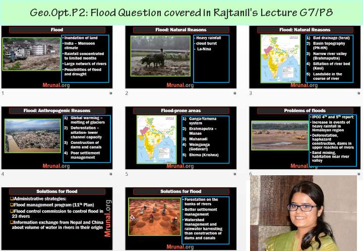
- Account for the growing frequency and intensity of floods in India, and suggest short- and long-term remedial measures indicating the chronically flood prone areas. Covered in Rajtanil’s lecture G7/P8
- How does climate change affect the- process of desertification of India?
- Discuss the scope of replication of White Revolution’ in lndia.
Paper-2: Section-B
Q5. Answer following: 10×5=50marks
- On the outline map of India provided to you, mark the locations of all the following. Write in your QCA Booklet the significance of these locations, whether physical/ commercial/ economic/ ecological/ environmental/ cultural, in not more than 30 words for each entry : 2×5=10
- Nokrek
- Gorakhnath Peak
- Indrakiladn Peak
- Polavaram
- Ananimudi
- “Age-sex pyramid is representative of the history of a region.” Explain (In about 150 words)
- “Mono-functional towns are economically vulnerable.” Discuss. (In about I5O words)
- Explain how change in land use can promote eco-development at different levels in the country. (In about 150 words)
- Discuss the social and spatial ramifications of increasing longevity. (In about 150 words)
Q6: 20 + 15 +15 marks
- Decentralized planning through the strengthening of the Panchayat system is the focus of planning in India in recent times. Suggest a blueprint for an integrated regional development plan.
- In population planning, the thrust of the Government has been ‘planning the population’ not ‘plan for the population’. Elaborate.
- Is planning for a cluster of villages a viable option, when planning for backward areas of the country? Discuss with suitable examples.
Q7: 20 + 15 +15 marks
- Reduction in regional disparities has been one of the priority goals of national planning in India. How the proposed new Smart urban centres may contribute to the process? Covered in Mrunal’s Mains revision series lecture ML1/P2
- How has India’s ‘Look East’ policy taken shape in the past two decades and how it may affect India’s external trade?
- Indian island territories are vulnerable to the sea level rise. Explain.
Q8: 20 + 15 +15 marks
- Discuss The concept of multi-level planning as practised in India, and explain the implications of 73rd and 74th constitutional amendments in this regards.
- Give a reasoned account of river water disputes related to the River Krishna
- Outline the Ghats. Government of India’s strategies of conservation of the Western Ghats.
![[Download] Topicwise UPSC GSM2-2023 Paper- polity, Governance international relations in Hindi and English with topic wise analysis](https://mrunal.org/wp-content/uploads/2023/09/ana-gsm2-2023-mrunal79-500x383.png)
![[Download] Topicwise UPSC Mains General Studies Paper-1 (GSM1): History, Geography, Social Science](https://mrunal.org/wp-content/uploads/2021/10/mains-answer-writing-d1-500x383.jpg)
Sir, kindly give information about pol science optional as well on the lines of geography . thank u :)
was it tough or easy ? can anyone who gave exam tell about the paper
IT WAS TOUGH .. HOW CAN MEMBERS OF UPSC THINK AGAINST OF STUDENT
paper 1 looked not like a geography paper itself..wrote vague answers for about 60 marks. many questions from human geography ruined the mindset. need to focus on whole syllabus it seems rather than focussing on selected physical geography units. one who gets above 230 in this paper would b a master in geography..
do you advise for taking Geography for next year?
Books for geography optional. I am from non geography background.
Ya..the paper I of geography was really not favorable and normal….120 would be the toppers mark….paper II was ok…but sort of GS paper rather than geography…..120-125 plus marks may be fetched in P-II. But due to Paper-I this time Geography people will be in great loss..this is my own perception…
Thanks Sir please upload gs papers3&4
Maths optional
1st paper was worst paper of geography..
please upload Mechanical paper….
Paper-2 is not regular paper…very unusual questions….Paper-1 has 70% regular questions
Please upload Political science and ir question paper too.
Surely get 280 + marks
bhaaiii mere to 350+ aarhe hain…tu itna peeche kaise reh gya…iswar tera bhala kare..
Good for u..I ll be happy with my 285+
In map question is it Narcondam island or narcodam?
Where is Indrakiladn Peak?
island indrakiladri -vijayawada-andhra pradesh famous durga temple
Thanks Hari.
If anybody wants commerce paper, can ping me on 9445960433 through whatsapp
Please upload chemistry papers if possible
Thank you.
Scope for Geography Paper 1 is too vast, apart from 3 to 4 straight questions such as koeappen Cs climate, meridonial circulation frontogenesis, pelagic deposits, you hardly find regular questions especially when it comes to human geography one need to apply themselves while framing an answer which really consumed lot of time as a result of it I was unable to complete whole paper…had attempted only for 205 marks out of which quality is maintained for 170 marks…
Geography 2 is quite general, especially all those questions related to Agriculture are quite similar in one way or another, one has to stretch the same concept again and again to accommodate different answers, however the paper can be completed within 3 hours unlike first paper….
I feel people who opted for geography optional paper1 has a disadvantage over other optional such as Public administration…Don’t know, I might be generalizing things here or might be rationalizing things to suit my version of truth….appreciate difference of opinion..
I do agree by your statements but what about scaling of marks.( Although its difficult to understand but what to do sole prerogative lies on UPSE.)
Sorry for typo UPSC
hdd yar.. Galti krdi kya geo optional Leke..
Why these questions appear to be so tough?
Engg. ke theory papers bade easy malum ho rahe hain..
Hello sir,
Please upload electrical engg paper 2015 IAS.
Fully agreed with mahi’s comments for Geography Paper-I…..
sir pls send political sc + GS Ppr -4 qstn papers of upsc 2015.
Geography paper one is definitely tougher than most of the popular optionals, now it all depends on scaling..
yupp absolutely right geo paper 1 was not as expected..nobody is sure to get about 120 or even 100 except FEW…well i too among normal not in few..hoping for good result with all of you..
questions like nelsons classification and alluvial fan are both applied and tough as well..
what do you think friends..
I heard UPSC has some mechanism to provide level playing to all optional subjects …. if that is true , they examiners will give generous marks to Geo opt-1 answer sheets based on guideline set by head examiner. If that does not happen, I will expect avg 100 marks in each paper. (Opt 2 has several ‘same’ questions on developments) .
Can geography optional be prepared in 3 months ?
You will need atleast 6 months to familiarize yourself with the whole syllabus of geography..questions being asked this year were not favorable even to those who have studied geo for more than an year..
Geography paper 2 was quite good.However as suggested by many, Paper 1 was very much aligned towards concepts like environmental,human geography than compared to physical or climatology.
respected sir kindly provide me law optional papers 2015 in hindi
Leavin Geog for good
Leaving Geography for good
Sir plz give some questions for answer writing for geography optional.
Please sir geography ka questions donload kijiye thanks sir please