
- Prologue
- Environment: Theory
- Environment: Current Affairs
- Geography: Physical
- Geography: Indian
- Geography: Map Based
- World Geography
Prologue
- [T25] series contains 25 Mock MCQ for UPSC IAS/IPS Civil Service exam aspirants.
- This particular article, gives you practice questions from Geography and Environment.
- Timelimit: 30 minutes.
- 2 Marks for correct answer; -0.66 marks for wrong answer.
Environment: Theory
Q. Statement I : Global warming signifies the rise in global surface temperature. Statement II : The increase of concentration of greenhouse gases in the atmosphere causes the rise in global surface temperature. (CDS-2017-ii)
- Both the statements are individually true and Statement II is the correct explanation of Statement I.
- Both the statements are individually true but Statement II is not the correct explanation of Statement I
- Statement I is true but Statement II is false
- Statement I is false but Statement II is true.
HINT: Global Warming is the warming of the Earth’s average global temperature because of an increase in the concentration of greenhouse gases. (NCERT Geography Class11 Glossary page 143). So Global warming is not merely a ‘surface’ temperature rise.
Q. Find correct statement(s) related to Carbon Dioxide (MCQ inspired from CDS-2017-ii)
- National Air Quality index doesn’t measure the level of CO2.
- Biogas is a mixture of Methane and carbon di-oxide.
- One carbon credit equals 100 kilos of Carbon Dioxide.
Answer Codes:
- Only 1 and 2
- Only 2 and 3
- Only 1 and 3
- All of them
HINT:
- AQI considers eight pollutants (PM10, PM2.5, NO2, SO2, CO, O3, NH3, and Pb) for which short-term (up to 24-hourly averaging period) You should read more theory on this pib page:
- Biogas is a mixture of methane and carbon-di-oxide. [NIOS page 70]
- One carbon credit equivalent of one metric ton of carbon dioxide. 1 Metric tonne = 1000 kilos.
Q. ‘Xeriscaping’ is a concept related to (CDS-2017-ii)
- landscaping related to save water
- landscaping related to save soil erosion
- weathering of rock surface
- all of the above
HINT: Xeriscaping is a method of garden design which involves choosing plants that can be maintained with little water. [TheHindu]
Q. A biological community in its environment such as a pond, an ocean, a forest, even an aquarium is known as (CDS-2017-ii)
- biome
- community
- abiotic environment
- ecosystem
HINT: NIOS Environment
- Biome: A large community unit, characterized by a major vegetation type and associated fauna, found in a specific climatic region, e.g Tundra Biome.
- Ecosystem: A communities of organisms and their physical environment, interacting as an ecological unit. The term ‘ecosystem’ was coined by A.G. Tansley in 1935. An ecosystem is a functional unit of nature encompassing complex interaction between its biotic (living) and abiotic (non-living) components. For example- a pond is a good example of ecosystem.
Q. Desalination of seawater is done by using reverse osmosis. The pressure applied to the solution is (CDS-2017-ii)
- larger than osmotic pressure
- smaller than osmotic pressure
- equal to osmotic pressure
- equal to atmospheric pressure
HINT: If a pressure higher than the osmotic pressure is applied to the solution side, the direction of flow of the solvent can be reversed. As a result, the pure solvent flows out of the solution through the semipermeable membrane. This process is called reverse osmosis. It is of great practical application in desalination of sea water to obtain pure water. [NIOS Chemistry page 223]
Environment: Current Affairs
Q. ‘Tuvalu’ has become a point of discussion recently. Why ? (CDS-2017-ii)
- potato plant that could grow in high altitude.
- Place in equatorial Africa, where snow is found
- New innovative technology to meet global warming
- A country under threat of submergence due to ice melting and sea level rise.
HINT: Tuvalu is a small island nation in the South Pacific / Ocenia and home to about 10,000 people. It is likely to be under water in less than 70 years. TheHindu 2017-May.
Q. Correct statements about World Environment Day which is organized by the United Nations? (inspired from CDS-2017-ii)
- It is celebrated on 5th June each year.
- Theme of 2018 was “Beat Plastic pollution”, and it was held in New Delhi.
- Theme of 2017 was “Connecting People to Nature – in the city and on the land, from the poles to the equator”, and it was held in Ottawa, Canada.
Answer Codes:
- Only 1 and 2
- Only 2 and 3
- Only 1 and 3
- All of them
HINT: For faster revision, all correct.
Q. Which one of the following statements about the Global Environment Facility Grant Agreement, signed by India in August 2017 with the World Bank for ‘Ecosystems Service Improvement Project’, is not correct ? (CDS-2017-ii)
- The size of the project is about USD 25 million.
- The duration of the project is 15 years
- The project will entirely be financed by the World Bank out of its GEF Trust Fund.
- The Ministry of Environment, Forest and Climate Change will implement the project.
HINT: According to PIB release:
- The objective of the Project is to strengthen the institutional capacity of the Departments of Forestry and Community Organisations to enhance forest ecosystem services and improve the livelihoods of forest dependent communities in Central Indian Highlands.
- The size of Project is USD 24.64 million which entirely will be financed by the World Bank out of its GEF Trust Fund.
- The project’s duration is 05 years.
- Ministry of Environment, Forest and Climate Change (MoEF&CC) will implement it.
Q. Correct statement(s) about Goldman Environmental Prize? (Inspired from CAPF-2017)
- This prize honors individuals and organizations in world’s six inhabited continents.
- Prafulla Samantara who led a historic legal battle for the indigenous Dongria Kondh’s land rights over Niyamgiri Hills against aluminum ore mining, is among the recipients of 2017’s award.
- Winners receive a bronze sculpture called the Ouroboros- a serpent biting its tail.
Answer Codes:
- Only 1 and 2
- Only 2 and 3
- Only 1 and 3
- All of them
HINT:
- Only grassroot ‘individual heros’ from world’s six inhabited continental regions: Africa, Asia, Europe, Islands & Island Nations, North America, and South & Central America.
- Prafulla Samantara is among the six winners for 2017.
- Ouroboros serpent sculpture is given as a symbol of nature’s power of renewal.
Geography: Physical
Q. Which of the following statements related to latitude are true ? (CDS-2017-ii)
- Rainfall, temperature and vegetation vary with latitude.
- The difference between the longest day and the shortest day increases with latitude.
- Indira Point is located approximately at 6°45’N latitude.
Select the correct answer using the code given below.
- 1 and 2 only
- 1 and 3 only
- 2 and 3 only
- 1, 2 and 3
HINT: Southern most point of the country as a whole lies further south in Andaman and Nicobar Islands. It is now called Indira Point. It is situated at 6°30’N latitude. [NIOS Geo page2.]
Q. Match List — I with List — II and select the correct answer using the code given below the Lists : (CDS-2017-ii)
List — I: Lake
|
List — II: Type of Lake
|
Code : A B C D
- 3 1 2 4
- 3 2 1 4
- 4 2 1 3
- 4 1 2 3
HINT: Ref: Majid Hussain’s Geography of India page.3.32</p
- Maharashtra’s Lonar lake is a crater lake
- Ashtamudi is a Lagoon.
- Garwal’s Gohna lake was formed by Landslide across a tributary of Ganga.
- Bhimtal is situated in Uttarakhand’s Kumaun division. Most lakes in Kashmir and Kumaun are tectonic lakes.
Geography: Indian
Q. Match List — I with List — II and select the correct answer using the code given below the Lists : (CDS-2017-ii)
List — I: Concern
|
List — II: [Product]
|
Code : A B C D
- 2 1 4 3
- 2 4 1 3
- 3 4 1 2
- 3 1 4 2
HINT:
- TISCO The Tata Iron and Steel plant lies very close to the Mumbai-Kolkata railway line. NCERT India People and Economy. (So A:2)
- Bharat Electronics Limited (BEL) a Navaratna PSU, was established in 1954. India Yearbook (So D:3)
Q. Which one of the following tribal groups is dominantly found in the Blue Mountains? (CDS-2017-ii)
- Lambadas
- Gonds
- Jarawas
- Todas
HINT: Todas of Nilgiri Hills are known for their skill in wild life protection. NIOS Geo P16.
Q. Which of the following statements in respect to the Indian Peninsular Plateau are correct? (CDS-2017-ii)
- The Deccan Plateau gradually rises from North to South.
- The Malwa Plateau dominates the Vindhyan scarps, forming the Eastern flank of the plateau.
- The Western Satpuras separate the Narmada and Tapi rivers.
- The Chota Nagpur Plateau is composed of Archaean granite and gneiss rocks.
Select the correct answer using the code given below.
- 1, 2, 3 and 4
- 1, 3 and 4 only
- 2 and 4 only
- 1 and 3 only
HINT:
- Chota Nagpur Plateau is composed of Archaean granite and gneiss rocks: Majid Hussain’s Geography of India page 26. So, 4 is right.
- Vindhyan hills form southern flank of the Malwa Plateus, so #2 is wrong.
Q. Which of the following statements is/are correct ? (CDS-2017-ii)
- Himalayan rivers have their origin in the snow-covered areas, hence are dry in winter season.
- Rivers of the Peninsular Plateau have reached maturity.
- Himalayan rivers depict all the three stages of normal cycle of erosion.
Select the correct answer using the code given below.
- 2 only
- 1 and 3 only
- 2 and 3 only
- 1, 2 and 3
HINT: Himalayan rivers are perennial in nature and depict all three stages.
Q. Statement I : The interior part of Maharashtra does not receive adequate rain in the summer season. Statement II : The interior part of Maharashtra lies in the rain shadow of the Western Ghats. (CDS-2017-ii)
- Both the statements are individually true and Statement II is the correct explanation of Statement I.
- Both the statements are individually true but Statement II is not the correct explanation of Statement I
- Statement I is true but Statement II is false
- Statement I is false but Statement II is true.
HINT: Arabian Sea branch of Southwest monsoons strikes the western coast of India and causes heavy rains on the western slopes of the Western Ghats. After crossing the Western Ghats, these winds cause less rainfall on the eastern slopes as they gain temperature while descending. This area is, therefore, known as rain shadow zone. This explains why interior parts of Maharashtra, Karnataka and Telangana get meagre rains from these winds. REF NIOS Geography page38
Q. Which one of the following statements about various horticulture crops of India for the year 2016 — 17 is not correct? (CDS-2017-ii)
- The area under horticulture crops has increased over previous year
- Fruit production during the current year is higher than the previous year
- Rate of increase in onion production is more than potato production in the current year in comparison to the previous year
- The major tomato-growing States are Madhya Pradesh, Andhra Pradesh , Karnataka, Odisha and Gujarat.
HINT: Madhya Pradesh doesn’t figure in the major tomato growing states. Ref: APEDA 2011 report.
Geography: Map Based
Q. Which one of the following does NOT pass through the Kaziranga National Park? (CAPF-2017)
- The Brahmaputra river
- The Diphlu river
- National Highway No.37
- Railway track of Indian Railway
HINT: UPSC examiner has surely made a vaguely worded question. Observe the map.
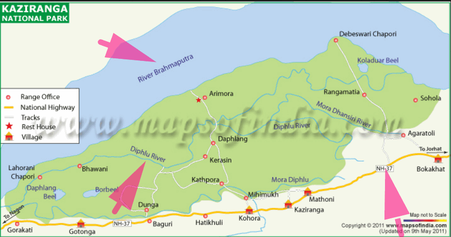
Highway and Brahmaputra river are adjacent to the park but don’t seem to ‘pass through it’. Railway track is definitely not passing through, although there were such proposals in 2016.
Q. Arrange the following Tiger Reserves of India from North to South : (CDS-2017-ii)
- Dudhwa
- Panna
- Pench
- Indravati
Select the correct answer using the code given below.
- 4, 3, 2, 1
- 2, 1, 4, 3,
- 1, 2, 3, 4
- 1, 3, 2, 4
HINT: Dudhwa : UP, Indravati: Chhattisgarh, Pench: Madhya Pradesh, Panna: Madhya Pradesh. Observe following map for exact sequence:

Q. Match List — I with List — II and select the correct answer using the code given below the Lists : (CDS-2017-ii)
| List — I: National Highway A. NH — 2 B. NH — 4 C. NH — 7 D. NH — 8 |
List — II: Route
|
Code :A B C D
- 3 4 2 1
- 1 2 4 3
- 1 4 2 3
- 3 2 4 1
HINT:
- National Highway No. 7 (NH 7), connecting Varanasi with Kanya Kumari, is the longest in the country. So C:4. [Ref: NCERT Fundamentals of Human Geography page 68]
- NH- 2 from Delhi to Kolkata. So A:3. [Ref: NCERT India : People and Economy p114]
Q. Which of the following lakes is/are situated in Ladakh: 1. Tso Kar, 2. Pangong Tso, 3. Tsomgo, 4. Tso Moriri ? (CDS-2017-ii)
- 1 only
- 2 and 3
- 1, 2 and 4
- 2 and 4 only
HINT: NCERT Class11: “….and salt water lakes
such as Pangong Tso and Tso Moriri are also in this (Ladakh) region. Alternatively, theHindu has verbatim answer: The natural high altitude salt water lakes — Tso Kar, Tso Morari and Pangong Tso, are a typical feature of Ladakh. ‘Tso’ means river in the Tibetan language. Ref: TheHindu March 2018
Q. Match List — I with List — II and select the correct answer using the code given below the Lists : (CDS-2017-ii)
List — I: Pass
|
List — II: Place
|
Code : A B C D
- 4 2 1 3
- 4 1 2 3
- 3 1 2 4
- 3 2 1 4
HINT: HP: Shipki La; Uttarakhand: Lipulekh; Sikkim: Nathu La and Jelep La.
World Geography
Q. Which one of the following islands is the largest? (CDS-2017-ii)
- Borneo
- Madagascar
- New Guinea
- Sumatra
HINT:
- Greenland – (840,004 sq. miles)
- New Guinea – (303,381 sq. miles)
- Borneo – (288,869 sq. miles)
- Madagascar – (226,917 sq. miles)
- Baffin – (194,574 sq. miles)
- Sumatra – (171,069 sq. miles)
Q. Match List-I with List-II and select the correct answer using the code given below the Lists : (CDS-2017-ii)
| List-I: (Industrial Region) A. Leipzig B. Detroit C. Lorraine D. Cumberland |
List-II: Country
|
Codes:
- A B C D:2 1 3 4
- A B C D:4 3 1 2
- A B C D:4 1 3 2
- A B C D:2 3 1 4
HINT: Detroit: USA, Leipzig: Germany, Lorraine: France.
Q. Match List — I with List — II and select the correct answer using the code given below the Lists : (CDS-2017-ii)
List — I: [Strait]
|
List — II: [Countries ]
|
Code : A B C D
- 2 4 1 3
- 2 1 4 3
- 3 4 1 2
- 3 1 4 2
HINT:
- NCERT Fundamentals of Human Geography Page 89: Packet Station / ferry ports occur in pairs located in such a way that they face each other across the water body, e.g. Dover in England and Calais in France across the English Channel. So it could be A or C.
- Florida = USA. Then eliminate accordingly between A and C
![[Download] Topicwise UPSC GSM2-2023 Paper- polity, Governance international relations in Hindi and English with topic wise analysis](https://mrunal.org/wp-content/uploads/2023/09/ana-gsm2-2023-mrunal79-500x383.png)
sir please post remaining BES 18 series.
Sir , can u please post the BES-2018 series
Sir please post the remaining articles of BES18….you are the last hope….no one can explain it better than you and by taking note of the remaining days left for pre it seems impossible to read and understand it from other sources
Sir please economy.
Some questions were very tough . i think upsc wont ask such trivial details in prelims
Thank you Sir
Sir ji, Bas Itna bata do ki baki part kab aayega..?? Aayega bhi ya nahi..???
Sir Please Take Interview of Mamta madam And Post on your site.
Madhya Pradesh -major tomato growing state
http://pib.nic.in/newsite/PrintRelease.aspx?relid=170400
Sir please bas BES series complete kar dena pre se pehle…because some people like me who are new and can’t afford coaching, are completely dependent on your series for economics ….Agir nhi hui toh we might fail prelims 2018.Thank you
Sir please upload BES SERIES
Sir,
We are waiting for next BES article.
Sir aap ka bahut samman hai UPSC ki duniya mei (As a selfless guy). If u have not completed BES there must be reason. I hope u r well and come back soon to help remote aspirants like me.
Thanks sir for providing best quality guidence.