
Analysis: Geography/EnB/Agro
| Geography |
|
| EnB |
|
| Agro |
|
Links to Answerkeys for CAPF-2013 exam
| Polity | 14 | Covered. Click me |
| EnB+Agro | 8 | Given in this article |
| Geography | 14 | Given in this article |
| Economy+IR+PIN | 21+4+2 | to be released soon |
| Science | 20 | to be released soon |
| History | 22 | Released. Click me |
| Aptitude | 20 | to be released soon |
| total | 125 |
Corrections, Additions post them in comments.
Geography
| Geography topic | 2012 | 2013 |
| Physical geography | 7 | 2 |
| World geography | 3 | 5 |
| Indian geography | 3 | 7 |
| Total out of 125 | 13 | 14 |
Indian Geography
Places/GK based
Q1. The place located at the confluence of Alakananda and Pindar rivers is
- Rudraprayag
- Karnaprayag
- Devaprayag
- Vishnuprayag
It is Karnaprayag, answer (B)
Ref. Page 116 Urbanization in Garhwal Himalaya: A Geographical Interpretation By Surendra Singh
Q2. Which among the following is nearest to the Tropic of Cancer?
- Aizawl
- Rajkot
- Kolkata
- Imphal
Observe the school atlas. Aizwal (Mizoram) is closest to Tropic of Cancer.
Q3 consider following
- Idduki: thermal power
- Sabarigiri : Hydroelectric Project
- Ghatprabha : Irrigation Project
- Ramganga : Multipurpose Project
Select the correct answer using the code given below.
- 2, 3 and 4
- 1, 2 and 4
- 3 and 4 only
- 2 and 3 only
| Idduki | Kerala. has dam and generates electricity through hydropower. So pair 1 is wrong. This eliminates B. |
| Sabarigiri |
|
| GhatPradbha | This River is one of the important tributaries of Krishna River and yes it does have irrigation project. This eliminates A and B. |
| Ramganga | yes in Uttarakhand. It has multipurpose project. Was in news in Jun2013 for security lapses. This eliminates D |
accordingly eliminate choices
(a) 2, 3 and 4
(b) 1, 2 and 4
(c) 3 and 4 only
(d) 2 and 3 only
hence answer is A: 2, 3 and 4
Mountain/Geology based
Q1. Incorrect Statement
- Shillong Plateau is an outlier of Peninsular Plateau of India
- Aravalli is the oldest mountain chain in India
- Vindhyas are fold mountains
- Rajmahal Highlands are composed of lava deposits
- Statement 1 is correct: Ref Student’s Britannica Page 6
- Statement 2 is correct according to DR Khullar’s Indian Geography book page 68
- Statement 3 is wrong because Vindhas are examples of Block mountains. Ref Page 201 Lucent’s GK book. Hence Answer is C
Q2. Which one among the following systems contains the oldest rock formation of India?
- Aravalli System
- Archean System
- Cuddapah System
- Vindhyan System
Archean system: a considerable area of peninsual India consists of Gneisses and Schists, which are the oldest rocks found in India. Hence answer (B)
Border Based
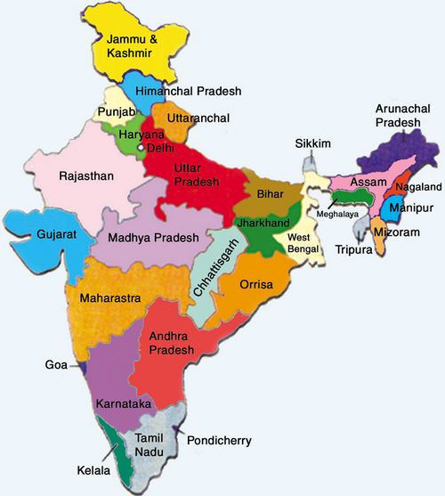
Q1. Which one among the following States shares common boundaries with maximum number of other States?
- Madhya Pradesh
- West Bengal
- Chhattisgarh
- Andhra Pradesh
Observe the school atlas:
| MP |
|
| WB |
|
| Chattisgarh |
|
| Andhra |
|
In short Chattisgarh wins. Answer is C
Q2. The State of Sikkim is surrounded by
- China, Nepal, Bhutan and West Bengal
- Bhutan, Nepal, West Bengal and Assam
- China, Nepal, West Bengal and Assam
- China, Bhutan, West Bengal and Assam
Observe the school atlas. Assam and Sikkim don’t touch each other. So eliminate B, C and D. we are left with answer A
World Geography
Q1 Match following
| (Continent) | (Desert) |
| A Asia | 1. Atacama |
| B Africa | 2. Mojave |
| C North America | 3. Kalahari |
| D South America | 4. Gobi |
Match ABCD to
- 4231
- 1324
- 4321
- 1234
Lucent’s GK book- chapter on Geography=> facts about each continent. Accordingly,
Asia=Gobi; Africa=Kalahari; S.America=Atkama and that leaves Mojave with N.America. Set the arrangement
| (Continent) | correct |
| A Asia | 4 |
| B Africa | 3 |
| C North America | 2 |
| D South America | 1 |
Hence answer C= 4321
Q2 Match the Following
| A Spree | 1. Bonn |
| B Rhine | 2. Hamburg |
| C Seine | 3. Paris |
| D Elbe | 4. Berlin |
Codes
| choice | A | B | C | D |
| a | 4 | 3 | 1 | 2 |
| b | 4 | 1 | 3 | 2 |
| c | 2 | 1 | 3 | 4 |
| d | 2 | 3 | 1 | 4 |
Correct pair is: Paris=Seine; Hamburg=Elbe; Berlin=Spree; Bonn=Rhine. Fit the options:
| river | correct city |
| A Spree | 4 berlin |
| B Rhine | 1 Bonn |
| C Seine | 3 Paris |
| D Elbe | 2 Hamburg |
Hence answer is B: 4132
Q3. Which one among the following ocean currents mixes with Labrador current?
- Canaries current
- Benguela current
- Florida current
- California current
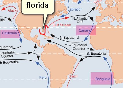
I haven’t been able to find a reliable source for this answer. But from the map of ocean current, it appears that: California and Benguela currents can’t possible mix with Labrador because they circulate in different regions. And from the movement of Florida and Canaries current- the most probably candidate to meet Labrador current is Florida current. So, Answer is C Flordia (or may be A. Canaries)
Q4. Which one among the following is the major occupation in equatorial region?
- Growing of tropical crops
- Growing of cereals
- Growing of citrus fruits
- Animal rearing
This question is lifted verbatim from Geography by Surender Singh, TMH Publication=>Section C mock question on Page 1323. Answer is A.
We can also cross verify from NIOS Geography, Lesson 14: Equatorial lowlands=>Topic Human response.
- Amazon: Plantation crops like Sugarcane, cocoa and bananas.
- Africa: Yam, Coffee, Cocoa. Agriculture has become an important occupation.
- Malaysia: Rubber an important plantation crop.
from these, we can deduct answer is A
Q5. The continent having the largest area in the equatorial belt is
- Asia
- South America
- Africa
- North America
I think South America but unable to locate a reliable source.
Physical Geography
Q1. Which of the following statements are correct?
- Sediments of Gondwana System were deposited under marine condition.
- Rocks of Gondwana System are fossiliferous.
- Rocks of Gondwana System contain metallic mineral deposits.
- Gondwana deposition took place in downfauIted trough.
Correct statement
- 1,2,3
- 1,2,4
- 2,4
- 1,3
From Vineeth Kumar’s comment:
Physical geography section:
question no 1:
answer:option (c).2,4
explanation: Gondwana rocks are faulted and make horsts and grabens.Gondwana basins are bounded by faults and deposition of sediments take place in such downfaulted basins.
That concludes 4th alternative to be correct and eliminates two alternatives(a,d).
Regarding first alternative: Gondwana group is made up of thick succession of continental sediments of fluviatile and lacustrine origin and not marine. Hence,proved
courtesy:Principles Of Engineering Geology,K.M.Bangar.
Q2. Which of the following statements regarding landslides is/are correct?
- They are sudden and sporadic.
- They result when the slope is gentle.
- Mining activity is also responsible for landslides.
Select the correct answer using the code given below.
- 1 and 2 only
- 1 and 3 only
- 3 only
- 1, 2 and 3
Refer to NCERT, Class 11 India Physical geography. Chapter 7, Page 90-91
- Landslides: Very High Vulnerability Zone=high rainfall regions with steep slopes in the Western Ghats and Nilgiris, the north-eastern regions. Thus Statement 2 is wrong. This eliminates A and D.
- Landslides due to mining and subsidence are most common in states like Jharkhand, Orissa, Chhattisgarh, MadhyaPradesh, Maharashtra, Andhra Pradesh, Karnataka, Tamil Nadu, Goa and Kerala. Hence statement 3 is correct. This eliminates A.
- It is always difficult to define in a precise statement and generalise the occurrence and behavior of a landslide.=Meaning Landslides are indeed sudden and sporadic. Statement 1 is right.
Therefore answer B: 1 and 3 only.
Environment and Biodiversity (EnB)
| topic | CAPF 2012 | 2013 |
| EnB | 10 | 5 |
- EnB’s importance reduced by 50%.
- In terms of difficulty, nothing unusual except Wallace line. And Chipko was a trap question if you didn’t know its link with alcoholism
- two MCQs can be directly solved from NCERT/NIOS.
Panda and WWF
Q1. The logo of which of the following famous organizations is a Giant Panda?
- World Wildlife Fund or World Wide Fund for Nature (WWF)
- International Union for Conservation of Nature and Natural Resources (IUCN)
- United Nations Educational, Scientific and Cultural Organization (UNESCO)
- United Nations Environment Programme (UNEF)
It’s Giant Panda=WWF. Answer A
Still Reference: http://www.britannica.com/EBchecked/topic/916482/WWF
Wallace Line
Q2. The Wallace’s Line distinguishes or separates the flora and fauna between
- Canada and USA
- Taiga region and Tundra region
- Mexico and Central America
- South-East Asia and Australasia
Man who does Ph.D like this?
Wallace’s line is an imaginary line postulated by AR Wallace as the dividing line between Asian and Australian flora and fauna in the Indonesian archipelago.
Hence answer is (D)
Ref: Page 57 Chloroplast DNA Variation in Indonesian Dipterocarpaceae By Sapto Indrioko.
Chipko
Q3. The Chipko Movement
- was an environmental movement to prevent cutting down of trees
- raised the question of ecological and economic exploitation
- is a movement against alcoholism as its broadened agenda
- demanded that local communities should have control over their natural resources
Select the correct answer using the code given below.
- 1 and 2 only
- 2 and 3 only
- 1, 3 and 4
- 1, 2, 3 and 4
Refer to Page 132-133 of Political Science, Avnindra Kumar Verma
| Women in this movement protested felling of trees by grabbing oak, rhododendron trees near their village. | 1 correct |
| Villagers demand that outsiders should be given no forest exploiting contracts.They asked government to provide low cost material to small industries. They even wanted Development of region without disturbing ecological balance. | 2 correct |
| The region’s forest contractors usually supplied alcohol to men. It forced women to launch sustained agitation against the habit of alcoholism. This broadened the movement’s angeda, to other social issues…..the Chipko movement which began on a single issue, became a symbol of many such movements in 1970s… | 3 correct |
| They even demanded that only local communities should have effective control over natural resources like land, water and forest. | 4 correct |
Hence Answer D: 1, 2, 3 and 4 all correct
Ozone Depletion
Q4. Statement I : Ozone is produced naturally by the action of ultraviolet radiation on oxygen molecule in the upper atmosphere.
Statement II : Ozone depletion has been caused by the release of chlorofluoro carbons (CFCs) into the atmosphere
- Both the statements are individually true and Statement II is the correct explanation of Statement I
- Both the statements are individually true but Statement II is not the correct explanation of Statement I
- Statement I is true but Statement II is false
- Statement I is false but Statement II is true
NCERT Class 12 Biology Chapter 12 Page 282 OR NIOS material on biodiversity- chapter 14, page 11
Both statements are individually correct. But Statement II doesn’t mention how CFC cause Ozon depletion (i.e. CFC release Chlorine atom and Chlorine reacts with Ozone.)
So, both statement individually correct but Statement II is not correct explanation of Statement I=>Answer B.
Autotrophs
Q5. Plants capable of performing photo-synthesis belong to which one among the following types of organisms?
- Heterotrophs
- Saprotrophs
- Autotrophs
- Chemoheterotrophs
NIOS material on biodiversity- chapter 5, page 2.
The green plants manufacture food for the entire ecosystem through the process of photosynthesis. Green plants are called autotrophs. Hence answer C
Agro
UPSC’s new found love for Agriculture is evident from its 2 Agro MCQS in CSAT 2013 and 3 Agro MCQs in CAPF 2013.
Coffee and Virgin soil
1. Statement I : Virgin soils of newly cleared forests give higher yield of coffee.
Statement II: Coffee is a soil nutrient exhaustive crop
- Both the statements are individually true and Statement II is the correct explanation of Statement I
- Both the statements are individually true but Statement II is not the correct explanation of Statement I
- Statement I is true but Statement II is false
- Statement I is false but Statement II is true
Radical History Review: Volume 70 by Cambridge University Press, Page 171
….coffee planters preferred to cultive lands cleared from primary forest, where nutrients were plentiful.
(In Brazil), Hundreds of old coffee trees were abandoned as planters migrated to new land and began again the process of clearing forests for humus and nutrients in their virgin soils.
From ^these, we can conclude Both statements individually correct and Statement II explains I. Hence answer is (A)
Micronutrients
Q2. The three primary soil micronutrients are
- carbon, oxygen and water
- copper, cadmium and carbon
- nitrogen, phosphorus and potassium
- boron, zinc and magnesium
Refer NCERT Science Class 9 chapter 15 page 206. They’ve given table for Micro and Macro nutrients.
| Micro | iron, manganese, boron, zinc, copper, molybdenum, chlorine |
| Macro | nitrogen, phosphorus, potassium, calcium, magnesium, sulphur |
Eliminate options accordingly
|
doesn’t fit the definition because Micronutrients=used by plants in small quantities. |
|
Wrong. Carbon doesn’t fit definition and Cadmium is toxic. Soil Microbiology, Ecology and Biochemistry By Eldor A. Paul, maintains that Cadmium not essential but found as toxic contaminant in soil. So that eliminates #2. |
|
wrong, all given in macro |
|
Wrong because magnesium is macro. |
- NCERT is not helping beyond this.
- Introduction to Agriculture, AK Vyas, Chapter 19 concurs with NCERT’s micronutrient list. (and this book is used by some UPSC players with Agri. optional)
- I digged on google books. Most of the agriculture related college textbooks maintain the same list of Micronutrients (given in above NCERT table.)
- Britannica lists copper, boron, zinc, manganese, and molybdenum. Again none of the options fit.
Hence two possibilities
- UPSC examiner wanted to ask about “Macronutrients” but typist wrote it as Micronutrients, else answer could have been C.
- UPSC examiner wanted to write Manganese but Typist wrote it as Magnesium. Meaning all four answers are bogus. Else answer could have been for D.
Either way, entire MCQ is wrong in its present format, unless someone wants to drag
Black Soil
Q3. Which one among the following is not correct regarding the black soils of Peninsular India?
- Rich in iron, lime and potash
- Retentive in moisture
- Fertile and well-suited for growing sugarcane
- Rich in phosphorus and organic matter
Refer NCERT Class 11 Indian Geography, Chapter6 Page71
Chemically, the black soils are rich in lime, iron, magnesia and alumina. They also contain potash..But they lack in phosphorous, nitrogen and organic matter.
Hence Statement D is incorrect. Answer D
Corrections, Additions post them in comments. Answerkey for remaining topics, coming soon.
thank u sir…
thnx
Thanx sir bit i had really a good laugh when i saw the explanation of Wallace Line (that Phd wala questn) and that micro nutrient wala questn
coffee is a soil nutrient exhaustive crop which is correct but in what sense does it explain the first statement so the answer should be option b bec both statements are tellin individual facts !so Mrunal bro correct me please
anyone who marked option b for this question ?
me also….
Ha ha … What you think? we correct
hahaha…lol…we thought we r correct that why we marked it..but mrunal may also correct…
ha yar b hoga…
i think b is right……….
Option-B has high chance to be correct but better not to take its mark in scoring to get conservative score.
whats your conservative score bro ?mine is 120
Guys i am expecting 155-165 marks what are my chances of clearing CAPF exam(written) ??
Start Running Rajveer…Last year the cut of was 96 only..But before predicting your marks you should wait for authentic answers from mrunal sir..
It doesnt matter if u score 200 in paper 1 unless u score atleast 60 in paper 2.
LOL and even of you score 250 in 1 and 200 in 2 but you cant run the run still doesnt matter.
Hmmm.. How it could be and “a” ..both statement r individually true.. Frnds ..tell me the expected cutoff as it was 97 last year
@Vinay : Cut Off in the sense for the whole 2 papers or for only 1st paper?
Thank you, Mrunal sir i think for question being chosen, A will be the answer.Refer article 102,it dont include 3rd point.
Thank you, Mrunal sir i think for question being chosen as,and for being a member of either house…. , A will be the answer.Refer article 102,it dont include 3rd point.
well done sir..! sir history ke question kafi confusing lag rhe hai. unko bhi analytically share kare thanks..
PHYSICAL GEOGRAPHY SECTION:
QUESTION NO 1:
ANSWER:OPTION (C).2,4
EXPLANATION: GONDWANA ROCKS ARE FAULTED AND MAKE HORSTS AND GRABENS.GONDWANA BASINS ARE BOUNDED BY FAULTS AND DEPOSITION OF SEDIMENTS TAKE PLACE IN SUCH DOWNFAULTED BASINS.
THAT CONCLUDES 4TH ALTERNATIVE TO BE CORRECT AND ELIMINATES TWO ALTERNATIVES(A,D).
REGARDING FIRST ALTERNATIVE: GONDWANA GROUP IS MADE UP OF THICK SUCCESSION OF CONTINENTAL SEDIMENTS OF FLUVIATILE AND LACUSTRINE ORIGIN AND NOT MARINE.
HENCE,PROVED
COURTESY:PRINCIPLES OF ENGINEERING GEOLOGY,K.M.BANGAR.
thanks Vineet Kumar. Answer updated.
sir
please clear my doubt on disqualification from house. please please
sir what will happen in case of wrong question like micro nutrient will there be a provision of bonus marks for attempt..??
see this R.T.I Sourabh:
https://mrunalmanage.wpcomstaging.com/2013/08/rti-upsc-indirectly-admits-settingup-bogus-question-in-apfcepfo-2012-written-exam-provides-official-answerkeys.html
sir
please clear my doubt on disqualification from house. please please
Wallace line reference was recently in Hindu (not more than a week or 2 back) on Indonesia ties or something.
It supports the fauna distinction, but is mute on flora distinction (so i guess the question is wrong!!!)
I tend to search such words after looking at the Cam ray Bhan question in one of the UPSC mains paper (which also incidently was referred to in Hindu, a week or two back – vietnam ties something article)
nice find Siddhanth.
my expectations are 115 in first paper and 80 in second paper…do i have any chance ?
i also in same condition plz tell me if you get some reply……………regards
Physical Geography
Q1. Which of the following statements are correct?
Sediments of Gondwana System were deposited under marine condition.
Rocks of Gondwana System are fossiliferous.
Rocks of Gondwana System contain metallic mineral deposits.
Gondwana deposition took place in downfauIted trough.
Correct statement
1,2,3
1,2,4
2,4
1,3
Depositional Environment:
The subsurface thickness of the Tertiary sedimentary prism is observed to increase gradually from west towards east. It is also observed that the depositional environment changes from brackish water over the shelf to marine condition in deeper basin.
Environments of Deposition. source (http://www.dghindia.org/Images/New-Head.gif)
so statement 1 is correct
Statement 2 is wrong it is carboniferous source 1 (http://books.google.co.in/books?id=EOgZJZaA-Q0C&pg=PA131&lpg=PA131&dq=Rocks+of+Gondwana+System+are+fossiliferous&source=bl&ots=6lsqRjQhVw&sig=NT4J8nJFAKnRIhOaJiXdj4XwKZ0&hl=en&sa=X&ei=F5NoUoTAN8TlrAe7m4GoCg&ved=0CDoQ6AEwAg)
source 2 The Gondwana system is regarded as the last massive formation of the stratified sedimentary rocks in the trough-basins of the Peninsula which were formed during the middle Carboniferous period. Huge quantity of alluvial matter was deposited in these basins over a long period of time starting from the UpperCarboniferous to the Jurassic periods.
The basins behaved as small geosynclincs yielding place to enormous thickness of rocks. Under favourable conditions of climate luxuriant growth of vegetation took place which was also buried under the debris during the Hcrcenian movement giving rise to coal seams. This system is designated as the Gondwana system after the ancient Gond kingdom in Madhya Pradesh where these rocks were first studied. Such formations also occur in Malaysia, Australia, S. Africa, South America and Anatarcatica to which the Indian landmass was previously tied up prior to the rupture of the super continent of the Gondwanaland.
The Gondwana system which took a long period of formation from Upper Carboniferous to the Jurassic periods indicates climatic changes. The system rests over a glacial boulder bed indicating a cold climate. This is followed by a hot and moist climate during which luxuriant vegetation thrived to form beds of coal. This flora is called glossopteris flora. This is followed by cold climate giving birth to greenish sandstones of the Panchet series. Then comes a period of hot and dry climate during which red sandstones and shales were formed. This is succeeded by warm and moist climatic condition producing Pillophyllum flora and forming new coal- seams.
Statement 3 is correct source (https://www.google.co.in/url?sa=t&rct=j&q=&esrc=s&source=web&cd=1&cad=rja&sqi=2&ved=0CCoQFjAA&url=http%3A%2F%2Fwww.resources.nsw.gov.au%2Fgeological%2Foverview%2Fstatewide&ei=2ZZoUq6fDYrprQfut4GACg&usg=AFQjCNGLa4SmAE9fNnFQuuBRTAZ5JKM-Dw&sig2=EBIShBkH0A5Tror7lsQisA&bvm=bv.55123115,d.bmk)
Statement 4 i have no information so answer is D 1 and 3
any correction please i welcome
appreciate your input Mohit
HI THERE,
@MOHITH YADAV
STATEMENT 2- GONDWANA ROCKS ARE FOSSILIFEROUS.
REMARK: PEFECTLY CORRECT LIKE MRUNAL’S ECONOMY ARTICLES.
WHY!…BECAUSE,GONDWANA FORMATIONS BEAR COAL SEAMS,I BELIEVE YOU MUST BE FAMILIAR WITH COAL FORMATION AND…
GONDWANA FAUNA:REPTILES-GONDWANASAURUS,ACTINODON
FISH-LEPIDOTES
MAMMALS-DICYNODON,LYSTROSAURUS
BIRDS-PTEROSAURUS,PTERADON
DINOSAURS-EPICAMPODON,BARAPASAURUS,ETC.
THOSE WERE THE “GONDWANA FAUNA” OF INDIA FOUND THROUGH FOSSILS,I M LAZY ON KEYPAD SO I WON”T TYPE “GONDWANA FLORA” FOR YOU.
CARBONIFEROUS :literally and spiritually pertains to carbon based organic forms of living matter.a basic idea of secondary level of chemistry will help u understand.
now STATEMENT 1:GONDWANA SEQUENCE DEPOSITED UNDER MARINE CONDITIONS
REMARKS:ABSOLUTELY CORRECT,
WHY!GONDWANA BASINS ARE RIFTED BASINS OF INDIA
EXAMPLE:NARMADA BASIN,GODAWARI – PRANHITA VALLEY,DAMODAR BASIN,MAHANADI GRABEN.
MARINE TRANSGRESSION HAPPENED AFTER GONWANA AGE.ie.DURING UPPER CRETACEOUS,EXAMPLES:SPITI,TRICHINOPOLY BAGH BEDS,etc.
FOR SURE SUCH GONDWANA BASINS ARE INCULCATED BY MARINE SEDIMENTS AT FRINGES OF THE SUBCONTINENT BUT THAT DOEST NOT TESTIFY THEIR MARINE ORIGIN.THEY STRICTLY BELONG TO FLUVIATILE AND LACUSTRINE ORIGIN.
SO,DON”T POST SUCH HOLLOW CONCLUSIONS WITHOUT A SUBSTANTIAL BASE AND JUST COPY PASTING A RANDOM SNIPPET FROM GOOGLE,WITHOUT PROPERLY UNDERSTANDING THE MATTER.
WHY SO SERIOUS!
Hi vineet bro ya agree i copy pasted but the truth remains same u can’t change how much u dig deep the depth will be more so exam is over so wait for Keys after exams over completed procedure UPSC itself releases i am very serious in proving the rascaldom of Teachers who makes silly mistake in this year CAPF exam paper 1 agro based question complete MCQ itself is wrong so if we argue the answer source is simply waste of time so don’t repeat this i am not telling i am right or u r wrong UPSC atleast have basic responsibility to check questions once spelling mistake or printing mistake it remains a mistake only, so prepare for exam not like this in proving others wrong don’t mistake me i am whole heartily welcomes ur comment just prepare for CSAT-14 time is very precious “one second” how much money we pay also we cannot get it back the “second” so be happy prepare well all the best for your future exams and future life
thank you
Mohith
when this results will be out?
Plz mail me….cpf ac2013 answer key
Mrunal Sir, Candidates were asked to attempt 4 short essays rather than 1 this year in the second paper. Is it indicative of a similar pattern for Civil services mains as well?
I think this time cutoff will go down bcoz paper was tough
Q5. The continent having the largest area in the equatorial belt is
ANS is Africa.
S. America has too small area towards north of equator than africa, whereas respective areas on south of the latitude are comparable.
what is the answer of gondwana question.
Africa has the largest area under the equatorial region
yes u r wright according to gs manual africa is the
right option
yeah.. africa has the largest area under equitorial region.. it is also the only continent that goes above tropic of cancer and below tropic of capricorn..
physical geog
Q1. Which of the following statements are correct?
1. Sediments of Gondwana System were deposited under marine condition.
2. Rocks of Gondwana System are fossiliferous.
3. Rocks of Gondwana System contain metallic mineral deposits.
4. Gondwana deposition took place in downfauIted trough.
Correct statement
A)1,2,3
B)1,2,4
C)2,4
D)1,3
Gondwana system exist in Saurashtra, MP, small patches of Chhattisgarh & northern AP; Ref: Oxford Student Atlas, India-Geology.
this region contains coal, lignite, gypsum and rock salt; so these rocks are fossiliferous (coal is formed from fossils) and these do not have metallic minerals. So, statement 2 is correct & 3 is false.
i.e. Options A) & D) are incorrect.
in both B) & C) statement 4 is correct. In Atalas also India-Structure map explains gondwana trough.
Now, statement 1 may be correct because Gondwana sedimentation occurred during Indian Subcontinent drifting & crossing of equator, 40-50 M years ago.
So, option B) or C) must be the answer.
nice deduction Hans. Check vineet kumar’s comment.
Regarding ques1 under physical geography ,I think the answer is C..
as coal in India are also known as Gondwana coal.(they are fossil fuels)..
do not not contain metallic minerals and were created because of tectonic activities(which results into down fault)
and I think its only petroleum is composed of marine fossil
Please correct me if I m wrong
hello every one what will be expected cutt off for capf ac 2013 this y
ear
Sir plz post study plan for up. lower subordinate exam.
it’s South America:: equatorial region marks from 5degree north to 5 degree south.
THe question is a trap, there is no standard def of equatorial region, so pray upsc thinks same as you marked. I went with south america, but clearly there is a longer equator on african land than south america.
The three primary soil micronutrients are…
its c answer…plz crct.
ref…
http://en.wikipedia.org/wiki/Plant_nutrition
with all respect, please cite a source other than wikipedia.
u can checkout also in books….
Agriculture & Fishery Technology Iii’ 2005 Ed.
By J. Dagoon
see page no.-4. ebook links are..
http://books.google.co.in/books?id=o8YIrkUGBMAC&pg=PA4&dq=primary+micronutrients+of+soil&hl=en&sa=X&ei=b2BqUsrUJ8WVrge4oIHQBw&ved=0CFAQ6AEwBg#v=onepage&q=primary%20micronutrients%20of%20soil&f=false
Dude NPK are given as Macronutrients..
BRO…THE QUESTION IS ASKING 3 MICRONUTRIENTS WHILE YOU ARE SUPPORTING YOUR ANSWER AS MACRONUTRIENTS…
bro…there is no any type of micro-nutrients.
actually three type of nutrient as
1.-primary macro-nutrients
2.-secondary macro-nutrients
3.-micro-neutrients
(according to many books)
sooo may b question wrong.
I have just quit my preparation and want to sell my books.
I have all major books/notes for GS/History/Philosophy
in Hindi Medium. I have few books in English Medium also. I also have printouts of Mrunal Sir articles on Economocs.
Interested aspirants please contact me.
Anshul Verma
9650033367
how much will be the approx cost of all material.
i am interested.
seems lyk the paper was neither too tough nor too smooth yet tricky, no doubt on dat.. upsc has playd dis ‘tricky’ card fairly wel.. n i gues mst f d aspirant arn’t as happy as they were 3 days bck.. nt satisfied yet hopng for the best.. cuttng d chase short.. am i the only 1 who thnks dat paper ws trickngly tough n hence expectd cut off cud cme down.. admin, students pls help on ths.. ab to bolna bnta h yr..
Sir,what is expected cut off for paper1 this year??