
- Difficultly level
- How to prepare Geography for CSAT-2015?
- [Act 1] Physical Geography
- [Act 2] India Eco/Human Geography
- [Act 2] India Map/location
- [Act 3] World Map
Difficultly level
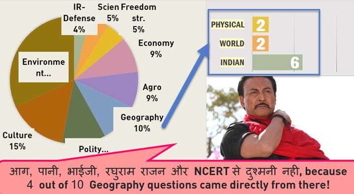
Although Danny usually underestimates the power of Bollywood heros but when it comes to CSAT, he crams NCERTs religiously
| 1.Glacial cycle | Medium. By common understanding both responsible but a player would hesitate before ticking in haste. |
| 2.Seasonal wind reversal | Easy. Verbatim answer in NCERT |
| 1.Changpa | Difficult. Because hard to memorize location and occupation of all tribes across India. |
| 2.Saree | Easy-to-medium depending on your taste for such economic geography factoids. |
| 3.Arunanchal rivers |
|
| 4. Hills & coasts | Same as above |
| 5.Highways | Difficult to recall three different national highways and their locations. |
| 6. 10 degree channel | Easy. Verbatim answer in NCERT |
| 1.Turkey location |
|
| 2.SE-Asia cities | Same as above. |
.vs CSAT 2013
| CSAT 2013 | CSAT 2014 |
|---|---|
| World geography 2 questions- one on map, one on climate | 2 Qs but both on map |
| Good no. of questions from NCERT class11 India Physical Geography | same |
| 1 MCQ on tribes of India | same |
| 1 Q on season | same (monsoon) |
| 1 Q on Narmada river | 1 Q on river but map/factoid type. |
| — | I’ve counted energy-wildlife sanctuary etc. questions under “environment”. We’ll see it in next article. |
.vs other exams
| CDS, CAPF | CSAT 2014 |
|---|---|
| Ridiculously difficult questions from geology and landforms- answers not even available in Goh Cheng & other routine books. | Thankfully, that lunacy is not repeated here. |
| CDS 2014: questions on rivers and hills | similar questions with parallel difficulty |
map based question
|
|
| Census related questions asked | nope |
| CAPF 2014: Physical geography “cause-effect” type questions that require ‘understanding’ of the topic. | Nope. Direct factoids / GK type. Just had to recall them. |
How to prepare Geography for CSAT-2015?
In CSAT-2014, majority of the geography questions could be solved through NCERTs and School Atlas. Therefore, preparation must begin from there:
- NCERT: Topicwise zip files available at Mrunal.org/Download
- School Atlas: Oxford OR Orient Blackswan
Physical Geography
| Topic | NCERT Subject and Chapter |
|---|---|
| Universe | Science Class 8 Ch.17Geography Class 6 Ch.1Geography Class 11 Ch 2. |
| Earth Basics | Geography Class 6 Ch.2 to 6Geography Class 11 Ch.1, 3 & 4 |
| Geology | Geography Class 11 Ch.5 to 7 |
| climate | Geography Class 11 Ch.8 to 12 |
| Ocean | Geography Class 11 Ch.13 & 14 |
| Disaster |
|
| Misc. | Geography Class 11 Ch.1 & glossary |
| After NCERTis done |
|
World Geography
| NCERT Class | Chapter |
|---|---|
| 7 | 7 to 10 |
| 8 | 1,3,5,6 |
| 12 (Human Geography) | 1 to 10 |
Lucent’s GK: if time permits, for famous cities, rivers, mount ranges and other GK
Indian Geography
| TOPIC | CLASS | CHAPTERS |
|---|---|---|
| Indiabasic | 6 | 7 |
| 9 | 1, 2, 4 | |
| 11 | 1 & 2 | |
| rivers | 9 | 3 |
| 10 | 3 | |
| 11 | 3 | |
| 12 | 6 | |
| Economicgeography | 10 | 1,5, 6, 7 |
| 12 | 7 to 12 | |
| HumanGeography | 9 | 6 |
| 12 | 1 to 4 | |
| AfterNCERT |
|
|
Related: how to prepare Geography for Mains GS paper1. Click me
[Act 1] Answerkey: Physical Geography
Q1: Evolution vs Glacial cycles
Which of the following phenomena might have influenced the evolution of organisms?
- Continental drift
- Glacial cycles
Select the correct answer using the code given below.
- 1 only
- 2 only
- Both 1 and 2
- Neither 1 nor 2.
Continental drift: 200 million years ago, that large continent Pangaea starts breaking up. Last Glacial cycle ended 15000 years ago. And as per the Geological timeline-table given in TMH, page 50-51, there were signs of evolution at both stages. Therefore, both events “might” have influenced the evolution. Anyways, for solid reference:
| Continental drift | One of the most prominent example of the effect of continental drift on evolution of organisms, is the unique primates found in Australia and South America. Ref.Google book#1 |
| Glacial cycle | The final stages of evolution of Genus Homo occurs in the last 3 glacial cycles. Ref google book#2 |
Therefore, answer C Both 1 and 2 correct.
Q2: Seasonal wind reversal
The seasonal reversal of winds is the typical characteristic of
- Equatorial climate
- Mediterranean climate
- Monsoon climate
- All of the above climates
Answer C because
- Class11 India Physical, Chapter 4 page 33: Monsoon connotes the climate associated with seasonal reversal in the direction of winds.=> Either C or D
- I couldnot find a source that says Equatorial climate involves “Seasonal reversal of Wind”=> D is eliminated, and we are left with “C”.
[Act 2] India Eco/Human Geography
Q1: Changpa people
With reference to ‘Changpa’ community of India, consider the following statement:
- They live mainly in the State of Uttarakhand.
- They rear the Pashmina goats that yield a fine wool.
- They are kept in the category of Scheduled Tribes.
Which of the statements given above is/are correct?
- 1 only
- 2 and 3 only
- 3 only
- 1, 2 and 3
- Lists Changpa under ST category from Jammu Kashmir.
- This means #1 is wrong and #3 is right. This eliminates A and D.
- Now everything depends on whether #2 is right or wrong.
- Pashmina: The Kashmir Shawl and Beyond follows the origin of the fibre right to the Changra goats, which are specially reared by the nomadic Changpa tribes of Ladakh, and then its refinement at the hands of the Kashmiri artisans and subsequent export and consumption by the rest of the world.
- Changpa tribe’s present population is less than 9,000, and the adverse climatic conditions which force them to keep moving 10 to 12 times a year.
- In Ladakh, merchants pay Rs.1,200 to 1,500 for a kilogram of raw Pashmina
Therefore, #2 is right hence answer B: 2 and 3 correct.
Counterview:
Question says “Pashmina goats”, but Hindu says “Changra goats”. And goats don’t give ‘wool’. Ans. Well, Tehlaka.com connects the dots:
- This area is also known as Rupsho Valley where the main occupation of the nomads is rearing yaks and Changra goats.
- The unforgiving winter makes the goats grow extremely warm and soft veneer, which is six times finer than human hair and is used to make Pashmina wool.
Therefore Changra goats = Pashmina wool. Answer B: 2 and 3 only.
Q2: Saree Towns
Consider the following towns of India:
- Bhadrachalam
- Chanderi
- Kancheepuram
- Karnal
Which of the above are famous for the production of traditional sarees / fabric?
- 1 and 2 only
- 2 and 3 only
- 1, 2 and 3
- 1, 3 and 4
#2 is right because official Madhya Pradesh Ashoknagar district website
- “Chanderi is a tehsil of Ashoknagar district ..main occupation of the people of Chanderi is handicraft. Chanderi sarees are famous all over the world”
- This fact is frequently asked in MP PCS exams, and eliminates Option D
#3 Kancheepuram is right by common knowledge, but for the sake of reference- Silk board of India
- temple towns like Kancheepuram are renowned for their magnificent heavy silk sarees of bright colours with silver or gold zari works
- This eliminates Option A.
| Bhadrachalam | Disputed village during separation of Telangana and Andhra Pradesh. I did not find any source that say it’s famous for saree. |
| Karnal | Was in news because some of its villages will be included in NCR (National capital region). While it’s infamous for low sex ratio and female infanticide, I did not find any source that says it’s famous for saree. |
Therefore, Answer B: 2 and 3 only.
[Act 2] India Map/location
Side note: I’ve counted wildlife sanctuary location questions under environment.
Q1: Rivers of Arunanchal Pradesh
1. Consider the following rivers:
- Barak
- Lohit
- Subansiri
Which of the above flows / flow through Arunachal Pradesh?
- 1 only
- 2 and 3 only
- 1 and 3 only
- 1, 2 and 3
Barak: Arunanchal Pradesh is wrong because
| NCERT |
|
| INDIA YEAR BOOK 2014 | Page 3 of – in third para-“The barak river , the head stream of Meghna rises in the hills in Manipur” |
Therefore, statement #1 is wrong, this automatically eliminates A, C and D. We are left with answer (B) 2 and 3 only.
Q2: Hills and Coasts
Consider these pairs
| 1. Cardamom Hills | Coromandel Coast |
| 2. Kaimur Hills | Konkan Coast |
| 3. Mahadeo Hills | Central India |
| 4. Mikir Hills | North-East India |
Which of the above pairs are correctly matched?
- 1 and 2
- 2 and 3
- 3 and 4
- 2 and 4
 NCERT Class11 India Physical:
- Refer to figure 2.2 on page10 of the same book. You can see Kaimur hills is in central highlands, far away from Konkan Coast.
- Therefore, pair #2 is wrong, this eliminates option A, B and D. Thus we are left with answer C.
Alternate references
- Spectrum Geography: Map showing important hills and mountain ranges.
- Page 10 Oxford student atlas 2nd edition 2014.
Q3: Highways
| National Highway | Cities connected |
|---|---|
| 1. NH 4 | Chennai and Hyderabad |
| 2. NH 6 | Mumbai and Kolkata |
| 3. NH 15 | Ahmedabad and Jodhpur |
Which of the above pairs is/are correctly matched?
- 1 and 2 only
- 3 only
- 1, 2 and 3
- None
| NH4: | Thane to Chennai via Pune belgaum Hubli Banglore and Ranipet ; |
| NH6: | Dhule to Kolkatta via Nagpur- Raipur- sambalpur |
| NH15: | Pathnkot and kandla via Amritsar- Ganganagar- jaisalmer. |
Therefore answer D all wrong. Ref
- TMH manual 2014.: Page 132- 133
- Lucent GK: Page 219
- Oxford student atlas: Page 41
Q4: 10-Degree Channel
Which one of the following pairs of islands is separated from each other by the ‘Ten Degree Channel’?
- Andaman and Nicobar
- Nicobar and Sumatra
- Maldives and Lakshadweep
- Sumatra and Java
NCERT Class11 India Physical, page 19: “The Andaman in the north and the Nicobar in the south are separated by a water body called 10 degree channel”. Therefore, answer A.
Alternate sources
- Page 29 of Oxford student atlas
[Act 3] World Map
Q1: Turkey Location
Turkey is located between
- Black Sea and Caspian Sea
- Black Sea and Mediterranean Sea
- Gulf of Suez and Mediterranean Sea
- Gulf of Aqaba and Dead Sea

Ans- B- Black sea and Mediterranean Sea, Reference- Page 55 of Oxford Student atlas 2nd edition 2014.
Q2: Cities of SE.Asia
What is the correct sequence of occurrence of the following cities in South-East Asia as one proceeds from south to north? 1.Bangkok 2.Hanoi 3.Jakarta 4.Singapore Select the correct answer using the code given below.
- 4-2-1-3
- 3-2-4-1
- 3-4-1-2
- 4-3-2-1

Ans- C (From south to north) Reference- Page 55 of Oxford Student atlas. For more answerkeys, visit Mrunal.org/answerkeys.

![[Errors/discrepancy] 16 MCQs where UPSC Official Prelims-2020 Answerkey & Coaching classes differ, while 2 MCQs cancelled](https://mrunal.org/wp-content/uploads/2021/11/csp2020-akey-differ-table-500x383.png)
Major hot deserts in northern hemisphere are located between 20-30 degree north and on the western side of the continents. Why?
SIR YOU WILL GIVEN SOME CHAPTERS LIST OF NCERT BOOKS THIS CHAPTERS ARE READING PRELIMS GOT HIGH MARKS COMPULSORY SIR PLZ TELL ME SIR
Hello! Sir,
Iam preparing for IAS 2017..plz suggest me which edition should i study of d following books:
1.Dr khullar’s india comprehensive geography.
2.selective study frm spectrum geography book.
Plz suggest me
Thanks in anticipation.
Khullar 3rd ed. 2014
In India- rivers section Class 11 3rd Chapter, I could not find anything relevant to Indian rivers. same with Class 12 chapter 6. Please help me out.
Dear Mrunal sir,
You have mentioned selective study in case of spectrum geography, please mention which chapters or sections are to be taken up for selective study…
Thanks
thank u
i think if they ask questions about sarees i will not make a mistake..:P
World famous silk saree Kahan bnti hai
Can any body guide me the needed strategy towards news paper reading as I am ending up my all energy and time engaging with the hindu news paper , unable to devote time for other subjects which is essential while going for priliminary exam . I need a definite plan.
thanks
appi
Thanku very much
for orisha psc(opsc) which are more impronant subject?and study plan for opsc prilim
Are the NCERT books referred here new or old??
respected sir,jo ncert ka chapter wise analysis kia hai vo bahut hi axa aur useful hai …thanx about it sir
but sir ye chapter jo apne topic wise diya hai vo new ncert se hai ya old ncert se …sir plz tell me?
I am rather bad at economics even it’s simple terminologies make me confused so what books will be read & I want to clear the exam through self study selecting study materials would be tough so a useful suggestion for it.
sr,indian geography syllabus me ncert class 6th ka chapter 7th for indian geography bt the chapter name is land of forests-democratic republic of congo which clearly not in indian geography plz solve problem,seemaab