
Prologue
- 14 out of 100 MCQs in CSAT 2013 were from Geography. Last year it was 11.
- Majority of the question can be solved directly from standard reference books/sources for Geography viz.
- NCERT
- NIOS
- General studies Manual
- Indian Geography by Majid Hussein
- Within Indian geography, agro related Qs. receive attention, just like last year.
- Within Physical geography, ocean, temperature related Qs, just like last year.
- World Geography continues to receive low-priority (Although world geography should not be completely ignored in preparation because Mains 2013 does contain topics from World Geography.)
- Nothing from current affairs.
Geography: Internal breakup

| World | 2 |
| Indian* | 6 |
| Physical | 6 |
| Total | 14 |
*Qs related to National parks, wildlife etc. classified under EnB (environment and biodiversity).
World Geography (2Qs)
Atlas Mountain Ranges
1. Which one of the following pairs is correctly matched?
- Abyssinian Plateau : Arabia
- Atlas Mountains : North-Western Africa
- Guiana Highlands : South-Western Africa
- Okavango Basin : Patagonia
In the school atlas, check the physical map of Africa. You’ll see Atlas mountain range in the Top-left corner (=north Western) => Answer B is correct.
Regarding other choices:
- Abyssinian plateau is in Ethiopia (in Africa)
- Guiana Highland= In South America
- Okavango basin/swamp= In Southern part of in Africa.
Hence final answer (B) Atlas Mountains : North-Western Africa.
Nomadic herders
2. “Climate is extreme, rainfall is scanty and the people used to be nomadic herders.” The above statement best describes which of the following regions?
- African Savannah
- Central Asian Steppe
- North American Prairie
- Siberian Tundra
let’s consider the options
African Savannah
Doesn’t fit the description of “Climate is extreme, rainfall is scanty”
Siberian Tundra?
- as per NIOS Geography material, chapter.16 Life In The High Latitudes
- Extreme climate= yes
- Low precipitation =yes.
- Nomadic life = yes
- but they’re not nomadic “herders”. Their primary occupation is hunting and fishing.
Central Asian Steppe
- as per NIOS Geography material, chapter.15 Life In The Mid Latitudes
- extreme climate= yes
- low precipitation =yes.
- Nomadic life= yes. The mid-latitude (Central Asian) grassland were once home to pastoral nomads like Kirgiz, Kazakh and Kalmuks.
North American Prairie?
- as per NIOS Geography material, chapter.15 Life In The Mid Latitudes
- extreme climate= yes
- low precipitation =yes.
- nomadic life? = No. The farmers here use mechanized equipment and do wheat cultivation on large scale.
Hence answer B) Central Asian Steppe
Indian geography (6Qs)
| Physical Geography of India (Narmada) | 1 |
| Minerals and Energy related | 2 |
| Agro related | 2 |
| Human Geography (Tribals) | 1 |
| Total | 6 |
Narmada
Q. The Narmada river flows to the west, while most other large peninsular rivers flow to the east. Why?
- It occupies a linear rift valley.
- It flows between the Vindhyas and the Satpuras.
- The land slopes to the west from Central India.
Select the correct answer using the codes given below.
- 1 only
- 2 and 3
- 1 and 3
- None
- Refer to NCERT 11th standard, Geography, 3rd chapter, page number 27. It says Narmada and Tapi flow through rift valleys caused due to the upheaval of Himalayas.
- Also it is given in the last line of the page as it flows through the rift valley with the Satpura in south and Vindhyas in the north. But there is no option for 1 & 2. We can consider maybe that flowing between the ranges may not cause the river to flow west and it is only a fact.
- Refer to NCERT Class 9 Contemporary India textbook, chapter 2, page number 10. It gives the contours of the Indian physical systems. We can see that Narmada is flowing through the area where the land is not sloping towards the west from central India, but it is flowing west because of the rift valleys only.
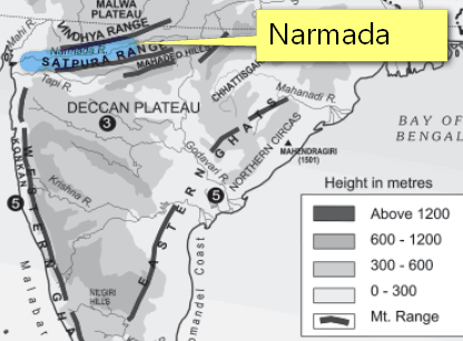
Hence answer (A) Only 1
Mica, Petrol and Gas
1. Consider the following statements:
- Natural gas occurs in the Gondwana beds.
- Mica occurs in abundance in Kodarma.
- Dharwars are famous for petroleum.
Which of the statements given above is/are correct?
- 1 and 2
- 2 only
- 2 and 3
- None
Refer to level 2 Q6 in Pearson’s General Studies Manual (2011), all three statements are directly lifted.
http://books.google.co.in/books?id=WuBFs6yFRwcC&pg=RA2-PA35&lpg=RA2-PA35
And as per Thorpe (author of the Manual) only Mica-Kordema Statement is correct.
http://books.google.co.in/books?id=WuBFs6yFRwcC&pg=RA2-PA55&lpg=RA2-PA35&ots=r3dPt0txsL
| Statement | T/F? | Why? |
|
False |
|
|
True |
|
|
False |
|
Hence answer: (B) only 2.
Coal, Indian
Which of the following is / are the characteristic/ characteristics of Indian coal?
- High ash content
- Low sulphur content
- Low ash fusion temperature
Select the correct answer using the codes given below.
- 1 and 2 only
- 2 only
- 1 and 3 only
- 1, 2 and 3
Standard reference books (NCERT, NIOS, TMH, Majid) are silent about low ash fusion temperature of Indian coal, hence time to dig internet.
As per an article published in Frontline (2008),
| most significant characteristic of Indian coal is its high ash content | 1st statement is correct |
| However, Indian coal’s sulphur content is low, about 0.5 per cent. | 2nd statement is correct |
| high ash fusion temperature of about 1,500 C. | 3rd statement is false |
Final answer A: only 1 and 2 correct.
Agro related (2Q)
Laterite Soil
1. Which of the following statements regarding laterite soils of India are correct?
- They are generally red in colour.
- They are rich in nitrogen and potash.
- They are well-developed in Rajasthan and UP.
- Tapioca and cashew nuts grow well on these soils.
Select the correct answer using the codes given below.
- 1, 2 and 3
- 2, 3 and 4
- 1 and 4
- 2 and 3 only
Indian Geography, Majid Hussain Chapter: Page 6.8
Laterite soils are rich in iron and aluminum but poor in nitrogen, potash, potassium, lime and organic matter. Hence Statement #2 is wrong. Eliminate all answer choices containing statement #2.
- 1, 2 and 3
- 2, 3 and 4
- 1 and 4
- 2 and 3 only
Thus we are left with final answer C: only 1 and 4.
Another approach is via NIOS Geography Chapter 19, Page 401
Laterite soil commonly found in areas of high altitude and heavy rainfall in Karnataka, TN, MP, Bihar, Orissa, Assam and Meghalaya. Hence Rajasthan doesn’t fit the bill. So, Eliminate choice involving Statement#3 and you’re still left with answer C.
Crop seasons
2. Consider the following crops
- Cotton
- Groundnut
- Rice
- Wheat
Which of these are Kharif crops?
- 1 and 4
- 2 and 3 only
- 1, 2 and 3
- 2, 3 and 4
Refer NCERT Class 12 Geography (India People and Economy), Chapter 5, Page no – 44
| Kharif | Rice, cotton, jute, juwar, bajra and tur |
| Rabi | Wheat, gram, mustard |
Hence answer must contain both Cotton (#1) and Rice (#3). And answer must not contain Wheat(#4).
Now start eliminating options
- 1 and 4 (because 3 is missing)
- 2 and 3 only (because 1 is missing)
- 1, 2 and 3
- 2, 3 and 4 (because contains 4)
Thus we are left with final answer C: 1, 2 and 3.
Tribals of India
Consider the following pairs :
- Limboo (Limbu) : Sikkim
- Karbi : Himachal Pradesh
- Dongaria : Odisha
- Bonda : Tamil Nadu
Which of the above pairs are correctly matched?
- 1 and 3 only
- 2 and 4 only
- 1, 3 and 4 only
- 1, 2, 3 and 4
As per the article that appeared in The Hindu in Feb 2012,
Bonda are the most primitive tribal groups in Odisha. According to Census 2011, the Bonda tribe has a population of less than 12,000. Therefore, statement #4 is wrong, because it links Bonda with Tamilnadu. Eliminate answer choices involving #4
- 1 and 3 only
- 2 and 4 only
- 1, 3 and 4 only
- 1, 2, 3 and 4
Thus, final answer (A): 1 and 3 only.
PHYSICAL Geography (5Qs)
Knight and Day
Variations in the length of daytime and night time from season to season are due to
- the earth’s rotation on its axis
- the earth’s revolution round the sun in an elliptical manner
- latitudinal position of the place
- revolution of the earth on a tilted axis
As per TMH General studies manual, Chapter Indian and World Geography, page 9
had the axis of earth been perfectly perpendicular to the plane of ecliptic, the sunrays would have been verticle over the equator all the year round and amount of energy received at any place would have remained constant throughout the year; hence no change of seasons. Also in that situation, the days and nights all over the earth would have been exactly equal throughout the year as it happens at the time of equinoxes.
Hence answer (D)
Fresh Water
On the planet earth, most of the freshwater exists as ice caps and glaciers. Out of the remaining freshwater, the largest proportion
- is found in atmosphere as moisture and clouds
- is found in freshwater lakes and rivers
- exists as groundwater
- exists as soil moisture
Refer to NCERT Class 11 Physical Geography, Ch.13, page 113
| Reservoir | Percentage of the Total |
|
97.25 |
|
2.05 |
|
0.68 |
|
0.01 |
|
0.005 |
|
0.001 |
|
0.0001 |
|
0.00004 |
Hence answer is (C) exists as groundwater.
Thunderstorm
During a thunderstorm, the thunder in the skies is produced by the
- meeting of cumulonimbus clouds in the sky
- lightning that separates the nimbus clouds
- violent upward movement of air and water particles
Select the correct answer using the codes given below.
- 1 only
- 2 and 3
- 1 and 3
- None of the above produces the thunder
The question is about cause of thunder during a thunderstorm (and not the cause of thunderstorm itself).
As per Britannica
- Thunder is the sound caused by a lightning discharge.
- Lightning heats the air in its path and causes a large over-pressure of the air within its channel.
- The channel expands supersonically into the surrounding air as a shock wave and creates an acoustic signal that is heard as thunder.
So is the answer D=none of above.
by the way if we take #2 is correct (lightening that separates numbus clouds), there is no option saying “only 2”.=> hence D
Temperature: Coastal vs Interior
The annual range of temperature in the interior of the continents is high as compared to coastal areas. What is / are the reason / reasons?
- Thermal difference between land and water.
- Variation in altitude between continents and oceans.
- Presence of strong winds in the interior
- Heavy rains in the interior as compared to coasts.
- 1 only
- 1 and 2 only
- 2 and 3 only
- 1, 2, 3 and 4
Debatable. first let’s check the statements that can be validated or rejected with surety:
Statement #1= correct
As per NIOS Geography, Ch5, Page 99
Continentality or distance from sea
- water is bad conductor of heat. Due to this moderating effect of the sea, places near coast have low range of temperature and high humidity.
- The places in the interior of continent do not experience moderating effects of sea. These places have extreme temperature. => Statement #1 is correct.
- This eliminates answer choice C, because it doesn’t contain #1.
Statement #4= wrong
- Statement 4 claims that Heavy rains in the interior as compared to coasts (are responsible for why annual range of temperature in the interior of the continents is high)
- But the interiors in Central Asia, receive very poor rainfall due to distance from sea. Annual precipitation is usually low in the interior areas. Hence #4 cannot be generalized.
- This eliminates choice D, because it contains #4. Thus we are left with two choices A and B.
- 1 only
- 1 and 2 only
So final answer boils down to whether statement #2 is right or wrong?
Relook at the question: it asks about why “annual range of temperature” is high in interior areas.
ok then, first What is annual range of temperature (ART)?
Ans. It is the difference between mean temperature of the warmest and the coldest months.
- We know that Shimla and Jalandhar are located @same latitude yet Shimla is cooler than Jalandhar because of difference in altitude. As we move up in the mountains, temperature goes down. but that is to justify difference in ART between two land-places.
- otherwise, if we look @the map showing ART in Costal vs Interior areas (see the map)

- Observe that Western Ghats and Himalayas have lower ART compared to coastal areas in TN and Andhra, Goa and Kerala coast.
- Therefore, Variation in altitude between continents and oceans= not the valid explanation for given question.
Hence #2 is wrong, answer= (A) only 1. (or debatable (B))
Update Jun-26-2014: UPSC uploaded official answerkey. Correct answer is: A.
Earth dynamic changes?
Consider the following:
- Electromagnetic radiation
- Geothermal energy
- Gravitational force
- Plate movements
- Rotation of the earth
- Revolution of the earth
Which of the above are responsible for bringing dynamic changes on the surface of the earth?
- 1, 2, 3 and 4 only
- 1, 3, 5 and 6 only
- 2, 4, 5 and 6 only
- 1, 2, 3, 4, 5 and 6
lolz, Debatable on what exactly is meant by “dynamic” changes on earth surface and how far we drag the logic about factors responsible such dynamic change.
Viewpoint #1: A is correct
- if you consider the tides that cause coastal erosion =dynamic change on earth’s surface. Then tides occur due to gravitational pull of the Moon=> #3 is right.
- earthquake =brings dynamic change on earth surface=>#4 plate movements is right.
- volcanos= brings dynamic change on earth surface=>#2 geothermal energy movements is right.
- Electromagnetic radiation, rotation, revolution cause seasonal changes
- Rotation =Responsible for day and night- cannot bring ‘dynamic changes’ to earth’s surface. So #5 is wrong (or implausible).
- Answer should contain 2,3,4 but not 5. only one such option=A: 1, 2, 3 and 4 only
Viewpoint #2: D is correct
- revolution of earth = responsible for seasons. And Heavy monsoon => landslides and soil erosion= dynamic change to surface. hence #6 must be in the answer. Therefore viewpoint #1 is wrong when it says #5 is wrong.
- final answer should be (D)= all six
Viewpoint #3: C is correct
- Electromagnetic radiation from Sun=> causes rainfall and snow melting=soil erosion=dynamic change to earth’s surface but it is a farfetched argument in terms of cause and effect because you’ve to factor in greenhouse gases, deforestation etc. Same goes for gravitational force, hence 1 and 3 are false, final answer (C) 2, 4, 5 and 6 only.
anyways, final arbitrator is official answerkey of UPSC.
Update Jun-26-2014: UPSC uploaded official answerkey. Correct answer is: D all of them responsible.
Answerkeys for remaining topics, coming soon + thanks Mr. Manu Jha (मनु झा) and Mr.Shiva Ram for providing help.
Thanx mrunal,
Can you please tell what will be cut-off for prelims this year
Variation in the duration of day and night from season to season is due to the latitudinal position of the place… NCERT Class 9, Chapter 1.. He asks a question that why is the duration btw day and night hardly felt in Kerala and highly felt in J&K??
And moreover at poles, sunlight is there throughout the day and night for 6 months and not there for the remaining 6 months…
evn I think the same. even WIKIPEDIA’s first line mentions about LATITUDE as a general reason for the variation. in any case earth does not revolves around its axis so option D is outrightly ruled out !!!! rotation is nyways not the reason for variation, hence LATITUDE seems to be most appropriate…
there are some answers which dont match with PD… Although both(Mrunal and PD) are reliabe,then which one should be followed…..
as per NIOS Geography material, chapter.16 Life In The High Latitudes but NIOS website is showing chapter 16 as India physical features.. am i refering to correct link or there is any other link?? please reply
regarding natural gas in gondwana beds…its given in the Economic survey book in chap 11 (energy) that shale gas formations are spread over sedimentary basins such as cambay,Gondwana,kg and cauvery…and i think this shld be the official answer of upsc as it is frm official book of goi..
What is annual range of temperature (ART)?
Ans. It is the difference between mean temperature of the warmest and the coldest months.
—>>it is quite correct as in northern hemisphere warmest(JuLY) and coldest (January)!!
but I THINK you missed
AVERAGE ANNUAL TEMPERATURE RANGE(AATR) =SUM TOTAL OF MEAN TEMPERATURES OF EACH MONTH IN A YEAR/12
THE MAP WHICH YOU DISPLAYED IS REFERRING AATR hence your explanation is wrong as it is no concerns with AAR.
Mr. mrunal i wish that you should analyze the definitions thoroughly i.e. “ANNUAL RANGE OF TEMPERATURE & average annual temperature range”.
REFER THE LAST TABLE OF ncert class IX ON PAGE 41.
*********variation in ALTITUDE IS NOT A FACTOR contributing to annual range of temperature after considering data given for KOLKATA,LEH,chennai,thiruvananthapuram,delhi.(altitude,jan & july temp difference)
$$$—leh is a part of HIMALAYAS HAVING HIGH ART!!
KINDLY CORRECT YOUR LINE OF THOUGHT—“Observe that Western Ghats and Himalayas have lower ART compared to coastal areas in TN and Andhra, Goa and Kerala coast.”
HOWEVER YOU ANSWERED IT CORRECTLY BASED ON YOUR MAP.HOW????
so it is not debatable at all as far as i think ART depends on
1.distance from sea(continentality)
2.latitude
3.OCEAN CURRENT(IF WINDS FROM SEA ARE DIRECTED TOWARDS LAND)
4.mountaion or relief “aspect”(example on west coast of north america NEVEDA–WHICH BLOCKS WINDS TO ENTER IN LAND FURTHER)
sir,
you are simply best. i appreciate the amount of hard work which you have put in compiling
and explaining each question (even wrong option for more clarification). may god fulfil your all wishes.
warm regards,
Raj
thunderstrom questions explanation is given in 7th class ncert of science and tech..it is due to lightning. .so mrunal is right…
thunderstrom questions explanation is given in 7th class ncert of science and tech..it is due to lightning. .so mrunal is right…..
During a thunderstorm, the thunder in the skies is produced by the
meeting of cumulonimbus clouds in the sky
lightning that separates the nimbus clouds
violent upward movement of air and water particles
Select the correct answer using the codes given below.
1 only
2 and 3
1 and 3
None of the above produces the thunder
i think answer for this is option c because most of the place where i searched solution for this question say answer is Option C
kindly please acknowledged the correct answer
Yes the correct answer is c :)
this is the best effort of you
Question of Mica, Petroleum and Gas. This question could have been very easy to answer if the candidate would have learned Indian Geology Time Scale (or the first chapter of Gepgraphy of India by Majid Hussain which is usually skipped or lightly taken). Petroleum in Dharwar system – Wrong because presence of fossils was available only from Mesozoic Era (Gondwana system), so petroleum will not available in the previous period.
answer of second questn is option D i.e. siberian tundra.
@Neeraj: Just because Venus doesn’t have seasons doesn’t mean Earth doesn’t experience changes due to rotation and revolution! You could argue that even day and night cause ‘dynamic’ changes on the Earth’s surface – the melting of snow on mounatains on a hot sunny day could be a ‘dynamic’ change as well! And the rotation of the earth also creates a centrifugal force which impacts tides.
I got this website from my pal who informed me concerning this site and at the moment this time I am visiting this web site and reading very informative content at this place.
I am really thankful to the owner of this web site who has shared this impressive article at at this place.
dharwar
The North-Western Region
This belt extends along Aravali in Rajasthan and
part of Gujarat and minerals are associated with
Dharwar system of rocks. Copper, zinc have
been major minerals. Rajasthan is rich in
building stones i.e. sandstone, granite, marble.
Gypsum and Fuller’s earth deposits are also
extensive. Dolomite and limestone provide raw
materials for cement industry. Gujarat is known for its petroleum deposits. -(ncert)
Why leh is colder than thiruvananthpuram?
Why dehradun and shimla are colder?
Thnqu sooo much….!!
Superb!!!
The tides are formed attracting force on the earth from sun and moon.
Sir,fact is more important or concept for upsc preliminary exam??
Select with the help of the codes given below, the components of Green Revolution :
1. High yielding variety seeds
2. Irrigation
3. Rural Electrification
4. Rural roads and marketing
Codes :
(A) 1 and 2 only
(B) 1, 2 and 3 only
(C) 1, 2 and 4 only
(D) All the four , ” this question some difficult please give explain sir
Dear Sir,
I am religiously following your blog and youtube channel. There is a discrepancy in both. In the question “Variations in the length of daytime and night time from season to season are due to” the youtube video as well as the Disha publication (21 years CSAT GS IAS) which you refer says the answer should be (b) whereas according to this blog or GC Leong the answer should be (d). Please clarify the doubt. Are we missing some points in the question or the answer provided by UPSC is wrong.
Thanks.
Waiting for some clarification.
Got clarification by scanning the comments on youtube.
Thanks for producing such a wonderful series of videos.
Variations in the length of daytime and night time from season to season are due to
the earth’s rotation on its axis
the earth’s revolution around the sun in an elliptical manner
latitudinal position of the place
the revolution of the earth on a tilted axis
As per TMH General studies manual, Chapter Indian and World Geography, page 9
had the axis of the earth been perfectly perpendicular to the plane of the ecliptic, the sun rays would have been verticle over the equator all the year round and the amount of energy received at any place would have remained constant throughout the year; hence no change of seasons. Also in that situation, the days and nights all over the earth would have been exactly equal throughout the year as it happens at the time of equinoxes.
Hence answer (D)
Sir if the answer to the question is (d) then why is the answer to this question is (b) in a book published by disha which says its exclusively solved by mrunal?